A Scenic Hike Around Kusasenrigahama in the Mt. Aso Area | HIKES IN JAPAN
イメージ

A Scenic Hike Around Kusasenrigahama in the Mt. Aso Area

Hike through a scenic area while viewing grand, large-scale mountain vistas forged by active volcanoes.
  • Duration
    1Day / 1Hours
    Highest Point
    1157m
    Elevation Gain
    21m
  • Skill Level
    Fitness Level
    Gear Level
Mt. Aso (Aso-san) is located in central Kumamoto Prefecture on the island of Kyushu, and is part of the Aso Kuju National Park. The Five Peaks of Aso (Aso Go-gaku) are: Mt. Nakadake, with its still active volcanic crater; Mt. Takadake, the highest peak in the range; Mt. Nekodake, with its steep ridges; Mt. Kishima (Kishima-dake), pock-marked with explosion craters; and Mt. Eboshi (Eboshi-dake), which is also known for the surrounding vast grasslands, called Kusasenri. Along with the great caldera landform that surrounds them, these mountains have been designated a UNESCO Global Geoparks. As of 2019, volcanic activity, including eruptions, has caused both Mt. Nakadake and Mt. Takadake to be declared off-limits to hikers. For this reason, the route introduced here covers the Kusasenrigahama grasslands from which you can view Mt. Aso’s peaks.

There are numerous facilities for tourists around the large parking lot adjoining the Kusasenri Aso Volcano Museum Bus Stop (Aso Kazan Hakubutsukan-mae Bus Stop) Bus Stop, including a museum, shops, a cafe, and a restaurant.

At the Aso Volcano Museum (admission fee: 860 yen), you can view educational exhibits about Mt. Aso as well as other volcanoes in Japan and around the world. You may also view screenings of volcanic eruption footage or take a guided tour. You can take a break at the café with its free Wi-Fi or the restaurant which offers dishes made from local ingredients.

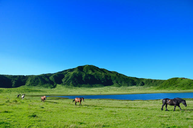
Kusasenrigahara grassland spreads out in a grassy expanse before you with horses grazing in some areas. Here, you may experience a safe horse riding activity with a supervisor leading the horse as you ride.

In Kusasenrigahara, at the base of Mt. Eboshi, there are two ponds and, some patches of grass that become beautifully scenic when they change color along with the changing of the seasons.

From the bus station, hike past the hill and within about an hour and 10 minutes, you can do a complete loop hike of Kusasenrigahara along a purpose-built walking path.

Other Info

With Mt. Nakadake currently inaccessible due to increased volcanic activity, it is recommended that you enjoy the view of the Mt. Aso’s volcanic mountain terrain while hiking up Mt. Kishima. Along the way, you can see such sights a now dormant crater at the summit and a water-filled crater lake located below the eastern slope. It takes about an hour and 30 minutes to complete your hike from the Kusasenri Aso Volcano Museum Bus Stop.

High Season:April to May, November

Notes

Due to ongoing volcanic activity in Mt. Aso, there are sometimes temporary changes to rules regulating whether you can enter the area. Please consult the following site, which also offers guidance in English, Chinese, and Korean, before visiting: http://www.aso.ne.jp/~volcano/

Route Map

Elevation Map

Height (m)
Horizontal Distance (km)

Spec

Duration
1Day / 1Hours
Highest Point
1157m(Mt. Komatateyama)
Elevation Gain
21m
Horizontal Distance
3.1Km
Skill Level
Fitness Level
Gear Level

On the Trail

Sleeping
-----
Eating

New Kusasenri

Hot-Springs

Hinoyama Onsen Dondokoyu

Instagram

more

Access

Mt. Aso is located in Kumamoto Prefecture on the island of Kyushu. From Haneda Airport, take a plane to Kumamoto Airport (approx. 1 hour 40 minutes).
From Kumamoto Airport, take a Kuko Renraku (airport shuttle) “Yamabiko” bus to Aso Station (approx. one and a half hours). From Aso Station, take a Kyushu Kotsu Bus Lines Aso Kako Line bus to the Kusasenri Aso Volcano Museum Bus Stop (approx. 30 minutes).

Links

COURSES

go to page topgo to page top

Cookies

This site uses cookies to analyze site usage, to optimize content and advertising, and to provide social media functions.
In order to access this site, you need to agree to the use of cookies.
Agree