


Mt. Nantai (Nantai-san) of the Nikko area is located within Nikko National Park in Tochigi prefecture. Selected as one of Japan’s 100 most famous mountains. The beautiful conical shaped-mountain rises on the northern shore of Lake Chuzenji (Chuzenji-ko), which is considered as the symbol lake of the Nikko area. Erected on the summit is the Okumiya (rear shrine) of Futarasan-jinja Shrine, which is one of UNESCO World Cultural Heritage Site “Shrines and Temples of Nikko”. This route introduces a round trip course from Chuguji of Futarasan-jinja Shrine, which is located between the shrine and Okumiya.
Hike of a Sacred Mountain, Mt. Nantai in Nikko Area
Round trip from the sacred shrine, Chuguji of Futarasan-jinja.
-
- Duration
- 1Day / 6.5 Hours
- Highest Point
- 2486m
- Elevation Gain
- 1212m
-
- Skill Level


- Fitness Level
- Gear Level
After submitting the hiking registration and paying the entrance fee at Futarasan-jinja Shrine Chuguji, enter the trail through the gate.
Hike straight up through the forest, then zigzag on the forestry road from the third station up. Approximately an hour of hiking from Futarasan-jinja Shrine Chuguji will lead you to the fourth station with a Torii gate.
The scenery changes from forest belt in bamboo grass field into slope with large rocks piled up, as you pass by the shelter hut on the fifth station. From there on rocky trail continues.
Pass by the shelter hut on the eighth station and hike up through a rocky section, the trail then becomes a set of wooden stairs built on the reddish-brown lapilli slope.
Passing through the point known as Midagahara, you will see less and less trees, and continue to hike through a rocky section of lapilli. Walk through the Torii gate, and you will arrive at the summit of Mt. Nantai, which is about 2 hours and 30 minutes away from the fourth station.
Other than Okumiya of Futarasan-jinja Shrine, facilities including the shrine office, shelter hut and belfry are on the summit area.
An iron sword is placed on a rock in the summit, pointing at the sky. Overlooking Lake Chuzenji, the view from the summit includes Mt. Shirane (Shirane-san) of the Nikko area, with Senjogahara Wetland in the foreground.
Take the same route for descending.
Gallery
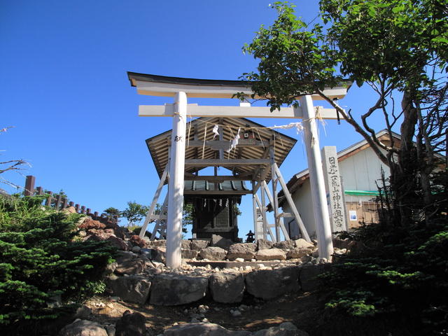
The Okumiya of Futarasan-jinja Shrine at the summit
Other Info
Futarasan-jinja Shrine Chuguji at the trailhead has a huge precinct, in which many shrine buildings and giant sacred trees called “Goshinboku” are interspersed, making the entire area the home of religious belief.
Shinto festivals are performed for the opening and closing of the hiking seasons, on May 5th and October 25th respectively, providing you the chance to experience the sacred atmosphere.
High Season:May to October
Notes
Mt. Nantai of Nikko is considered as a part of the precinct of Futarasan-jinja Shrine Chuguji, and entering the mountain during winter is prohibited. The season for hiking and worshiping is limited to about five and a half months, from May 5th to October 25th.
Route Map
Elevation Map
Height (m)
Horizontal Distance (km)
Spec
- Duration
- 1Day / 6.5 Hours
- Highest Point
- 2486m(Mt. Nantai)
- Elevation Gain
- 1212m
- Horizontal Distance
- 8.1Km
- Skill Level
- Fitness Level
- Gear Level
On the Trail
- Sleeping
- -----
- Eating
- -----
- Hot-Springs
Chuzenji Onsen


