


Towering in the central region of Hokkaido, Daisetsuzan is the general name for a volcanic group of 2,000-plus meter peaks that includes Mt. Asahi (Asahi-dake), Mt. Kuro-dake, Mt. Aka-dake, Mt. Hokuchin (Hokuchin-dake), Mt. Hakuun (Hakuun-dake), Mt. Pippu (Pippu-dake), Mt. Aibetsu (Aibetsu-dake), and Mt. Hokkai (Hokkai-dake). The area had been designated as Daisetsuzan National Park. Here, we will introduce a route that uses ropeways to reach the summit of Mt. Asahi, the highest peak of Daisetsuzan mountain range and in Hokkaido, Mt. Asahi, and traverse the ridge to Mt. Kuro-dake. It is a relatively easy way to hike the peaks of Daisetsuzan.
Traverse Hike of Daisetsuzan Mountain Range from Mt. Asahi to Mt. Kuro-dake
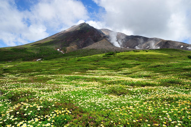
Traverse “the roof of Hokkaido” in a single day trip.
-
- Duration
- 1Day / 8Hours
- Highest Point
- 2291m
- Elevation Gain
- 772m
-
- Skill Level


- Fitness Level
- Gear Level
Get off the ropeway at Sugatami Station and walk along the stone paved path for about 20 minutes to reach Sugatami-no-ike Pond. After passing the Asahidake-ishimuro Refuge, the route becomes a proper mountain path. Hike up the rocky, heat-scorched slope running alongside an explosion crater. By this point, you will have ascended above the treeline to windy and barren terrain where no vegetation grows. You should exercise caution regarding weather conditions.
Hike up past two large rocks known as Nisekinko-iwa Rock and Kinko-iwa Rock, and you’ll arrive at the summit of Mt. Asahi in about 2 hours and a half minutes from Sugatami-no-ike Pond. Hike down the steep, rocky slope from the Mt. Asahi peak and pass a camping area below. Traverse the slope to the right of Mt. Kumagatake’s peak and hike up the other side to reach the junction to Mt. Mamiya (Mamiya-dake). From Mt. Asahi, it takes about an hour to get to the junction. From here, walk along the ridge that winds around the right edge of a volcanic crater called Ohachi-daira.
Continue beyond Mt. Mamiya and hike down the trail for another 20 minutes to reach the Nakadake junction. From here, hike up the slope to Mt. Naka-dake, then hike down a wide ridge to the Hokuchin junction and on to Mt. Hokuchin. At 2,244 m, Mt. Hokuchin boasts the second highest elevation in Hokkaido. It takes about 40 minutes to hike from the junction to the peak and back.
Next, hike down from the Hokuchin junction to the Ohachi-daira Observatory. From here, continue on through a segment of trail passing through a grassy area called Kumono-taira. This area blossoms into a flowery meadow from July to August. Hike down the gentle slope from Kumono-taira to arrive at the Kurodake-ishimuro Refuge. This hut operates from late June to late September and you may use the toilet or purchase goods here. From Kurodake-ishimuro Refuge hike uphill for about 20 minutes to the peak of Mt. Kuro-dake. Take a moment to look behind you for a good view of the traverse.
From Mt. Kuro-dake, hike down through grassy fields along a path fitted with steps and wooden walkways to reach Mt. Kuro-dake Seventh Station. From here, you can take the ropeway to complete your descent.
Gallery
Other Info
Throughout July and August, you can see fields of alpine flora at Sugatami-daira, Kumono-taira and around the middle section of Mt. Kuro-dake’s slope. The mountains in this range also start to display autumn foliage from as early as the end of August to the start of September. In this way, you can experience the effects of a short summer which is unique to Hokkaido’s high latitude mountains.
Best Season:July to September
If you go to this trail outside of the best season, you should pay attention to weather and trail conditions, as the mountain is located in a snowy area; there may still be snow on the trail in June, and it may start snowing from September.
Notes
At locations along the route such as Mt. Asahi’s explosion crater and Ohachi-daira’s toxic hot spring, volcanic activity causes harmful gas emissions. Beware of sulfurous gases which may waft downwind toward the walking path. On certain years, snow may remain on the down slopes of peaks like Mt. Asahi and Mt. Hokuchin until August. In such cases, you are advised to bring mini crampons with you.
Route Map
Elevation Map
Height (m)
Horizontal Distance (km)
Spec
- Duration
- 1Day / 8Hours
- Highest Point
- 2291m(Mt. Asahi)
- Elevation Gain
- 772m
- Horizontal Distance
- 18.2Km
- Skill Level
- Fitness Level
- Gear Level
On the Trail
- Sleeping
Kurodake-ishimuro
- Eating
Asahidake Ropeway
- Hot-Springs
Sounkyo Onsen


