


A Circuit Hike of Houou Sanzan from Aoki Kosen
-
- Duration
- 2Days / 13Hours
- Highest Point
- 2841m
- Elevation Gain
- 1753m
-
- Skill Level


- Fitness Level
- Gear Level
Set out from Aoki Kosen and hike up past the large dams in the river, continuing along the riverside trail. Once you enter the forest belt, the trail continues up and along the Dondoko-sawa mountain stream, which you can see below and to your left. The trail then turns into a steep, zigzagging path. After about two and a half hours after setting off from Aoki Kosen, you’ll arrive at Minami-shojiga-taki Falls. There’s a looping path, which you can hike around from the trail, leading to a vantage point with a view of a waterfall. From here, you can watch the water coursing through the white granite rock face and plunging down in a grand 70 meters high fall.
Hike further up the sloping trail through the forest belt to reach the junction with Houou-daki Falls. From the trail, you can hike to the falls and back in about 10 minutes. From this point, the trail gets even steeper and, after about an hour and a half of walking from Minami-shojiga-taki, you will reach Shiraito-daki Falls. Hike up about one more hour, and you will reach the fork to Goshikino-taki Falls, where you can hike to a spot quite near the waterfall and back.
Continue hiking up the trail as your field of view gradually opens up to reveal Mt. Jizo. At this point the trail gives way to a gently sloping path. After about 6 hours of setting out from Aoki Kosen, you will arrive at the Houou-goya mountain hut, where you will spend the first night of the trek.
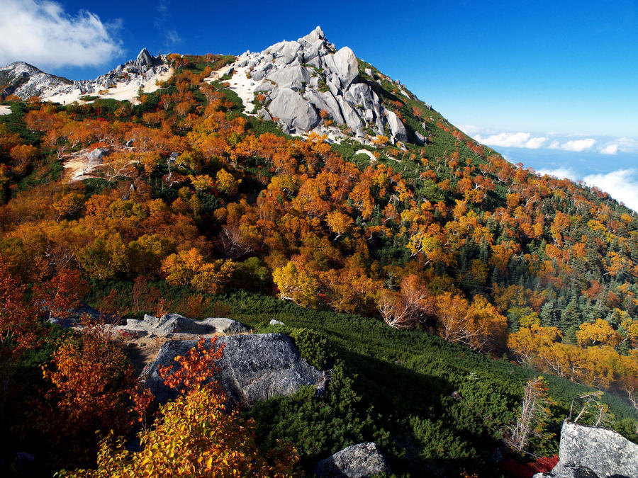
The second day begins with a hike to the most northerly of Houou Sanzan, Mt. Jizo. Hike up the wooden stairs through a forest that gives way to shrubbery, then continue up a steep sandy slope, taking care not to slip. After about an hour of hiking from the Houou-goya, you will reach a col called Saino-kawara. Hike up to the craggy peak of Jizo-dake (known as “the Obelisk”) and back. Then, from Saino-kawara hike up for about 10 minutes to reach Akanukesawano-kashira. From this point, continue southwest along the ridgeline. Descend along a sandy segment of trail passing between granite slabs where rock pine and shrubs grow. Then, go straight past the junction which braches off to the Houou-goya and hike up a rocky slope. It takes about 70 minutes of hiking from Akanukesawano-kashira to the next peak, Mt. Kannon.
Hike down a gentle segment of sandy trail from Mt. Kannon and continue on up the slope to Mt. Yakushi. It takes about 30 minutes to get from one peak to the next.
From the peak of Mt. Yakushi, continue left past the junction and descend the Nakamichi trail. From here, you will enter a forest belt and eventually come to a giant rock called Goza-ishi. Continue on through a steep segment of forested path which gives way to a stretch of bamboo grass. Hike down the zigzagging path and, after about 3 and a half hours of hiking from Mt. Yakushi, you will arrive at a forest road.
Walk along the level road through the forest for a further 40 minutes to return to the starting point, Aoki Kosen.
Gallery
Other Info
There are many Buddhist statues called Kosazuke Jizo (“child-granting” Jizo) positioned around Saino-kawara, beneath the peak of Mt. Jizo-dake. There is a custom whereby couples who have difficulty conceiving children take one of the Jizo statues home with them. If they then have a baby, they give back two Jizo statues as a token of gratitude, which accounts for the gathering of Jizo at Saino-kawara.
Currently, the local mountaineering club have a placed a 20 kg statue in the area.
Best Season:June to October
If you go to this trail outside of the best season, you should pay attention to weather and trail conditions, as the mountain is located in a snowy area; there may still be snow on the trail in May, and it may start snowing from October. Snow mountaineering equipements and experience are required during the winter season.
Notes
The route introduced here has significant changes in altitude as well as steep inclines on both the ascent and descent.
Although it increases the distance traveled, starting the traverse from the Yashajin-toge trailhead to the south side of the range decreases the altitude change by about 300 meters. From the Yashajin-toge trailhead, hike for about 5 and a half hours to reach the Minamiomuro-goya mountain hut, and a further hour and a half to reach Mt. Yakushi.
Route Map
Elevation Map
Spec
- Duration
- 2Days / 13Hours
- Highest Point
- 2841m(Mt. Kannon)
- Elevation Gain
- 1753m
- Horizontal Distance
- 14.5Km
- Skill Level
- Fitness Level
- Gear Level
On the Trail
- Sleeping
Houou-goya, Yakushi-dake-goya
- Eating
Aoki Kosen
- Hot-Springs
Aoki Kosen


