


Mt. Jiigatake and Mt. Kashima-yarigatake are mountains that constitute parts of the Northern Japanese Alps and southern Ushiro-tateyama Peaks, located on the prefectural border of Nagano and Toyama Prefectures. Mt. Kashima-yarigatake is selected as one of Japan's 100 most famous mountains.
Three-peaked Mt. Jiigatake and dual-peaked Mt. Kashima-yarigatake are both beautiful on their own, and has gorgeous views of Mt. Tsurugi (Tsurugi-dake) and the Tateyama Peaks.
This course introduces a round-trip route from Kashiwabara Shindo, which is well-maintained and comparatively easy to walk, and has two mountain huts.
Mt. Jiigatake and Mt. Kashima-yarigatake, Round Trip from Kashiwabara Shindo
Touring through the two beautiful mountains of the Ushiro-tateyama Peaks.
-
- Duration
- 2Days / 14.5Hours
- Highest Point
- 2889m
- Elevation Gain
- 1554m
-
- Skill Level


- Fitness Level
- Gear Level
The Kashiwabara Shindo Trailhead provides a parking lot, which gets congested with private cars of hikers during weekends and holidays.
Walk on the right bank of the stream for a while, until the trail turns into a zigzagging ascent through the forest belt. Pass through the edge of a precipice on the left and through the open space with a cairn, then the trail turns into a gently ascending traverse.
Walk pass the stone-paved area and the trail becomes flat and continues through the shrub zone, where the view improves.
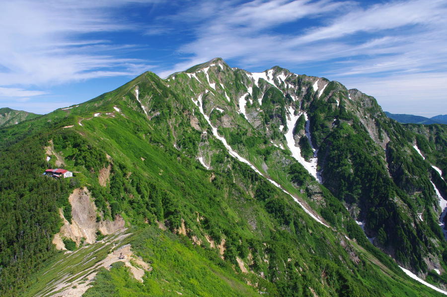
Passing the chain-supported area, hikers will arrive at Taneike-sanso mountain hut in approximately 3 hours and 30 minutes from the trailhead.
From Taneike-sanso, ascend on the ridgeline through the stone pine belt. The ridgeline provides wonderful view of Tateyama Peaks. Approximately an hour of hiking from the hut will take hikers to the southern peak of Mt. Jiigatake. Hike over the central peak and traverse through the west side of the northern peak and descend zigzagging on the ridgeline, and hikers will arrive at Tsumetaike-sanso mountain hut via Akaiwa-one fork in approximately an hour and 15 minutes. This is the place to stay for the first day.
Day 2. Set out from Tsumetaike-sanso and walk pass the camping area. Hike up the ridgeline in zigzags, and hikers will arrive at Mt. Nunobiki (Nunobiki-dake) in approximately an hour and 20 minutes.
Proceed on the ridgeline for approximately another 50 minutes, and hikers will arrive at the southern peak of Mt. Kashima-yarigatake. The other peak, the northern peak is approximately an hour and 10 minutes away round trip.
Take the same route back for the return trip.
Gallery
Mt. Kashima-yarigatake and Tsumetaike-sanso.
Other Info
Looking over to the west from the ridgelines of Mt. Jiigatake and Mt. Kashima-yarigatake, hikers can enjoy the beautiful mountains of Tateyama Peaks and Mt. Tsurugi. Especially the view of Mt. Tsurugi is impressive with its saw blade-like ridgeline of eight peaks (commonly called “Yatsumine”), along with the view of the Sea of Japan in the background.
Best Season:July to September
If you go to this trail outside of the best season, you should pay attention to weather and trail conditions, as the mountain is located in a snowy area; there may still be snow on the trail in July, and it may start snowing from October. Snow mountaineering equipements and experience are required during the winter season.
Notes
This course is a round-trip route. For the Day-2 hiking to the summit of Mt. Kashima-yarigatake, hikers can leave their excess baggage at the Tsumetaike-sanso where they stayed the day before.
Route Map
Elevation Map
Height (m)
Horizontal Distance (km)
Spec
- Duration
- 2Days / 14.5Hours
- Highest Point
- 2889m(Mt. Kashima-yarigatake southern peak)
- Elevation Gain
- 1554m
- Horizontal Distance
- 21.7Km
- Skill Level
- Fitness Level
- Gear Level
On the Trail
- Sleeping
Taneike Sanso, Tsumetaike Sanso
- Eating
Ogisawa Station, Restaurant Ogisawa
- Hot-Springs
Omachi Onsenkyo Yakushino-yu


