


Mt. Okue (Okue-yama) is located in the northern part of Miyazaki Prefecture, and is designated as one of Japan’s 200 most famous mountains. Trails are situated deep in the mountains and are referred to as the last untrodden region on Kyushu, with a succession of highly difficult rocky sections only experienced hikers can proceed. The standard time for summiting is over 10 hours, and with over 50 locations equipped with ladders and rope, it is recognized as the hardest mountain to climb in Kyushu. Among several hiking courses, this article introduces the circulating course from Wakuzuka to Bozu-one ridge that offers an outstandingly gorgeous view.
Mt. Okue: Circuit Hike from Kamihouri Trailhead to Wakuzuka and Bozu-one Ridge
Challenging the Most Perilous Mountain in Kyushu.
-
- Duration
- 1Day / 10Hours
- Highest Point
- 1644m
- Elevation Gain
- 990m
-
- Skill Level


- Fitness Level


- Gear Level
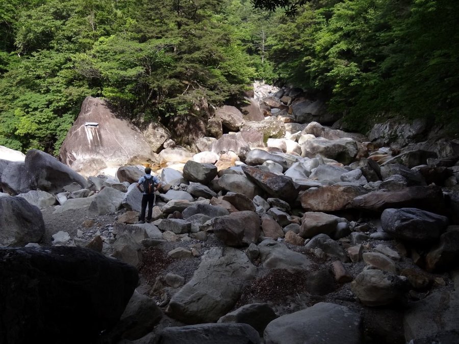
From Kamihouri trailhead to Wakuzuka fork, walk along Houri-gawa River on a gently sloping path. Passing Bozu-one fork on the way, it takes about an hour to get to Wakuzuka fork. You need to ford across Houri-gawa River here. Do not proceed unsafely if the water level is high, but return.
After fording the river, the real ascent begins, and rocky difficult spots appear one after another. Footprints are faint and many areas have very few marking tapes. Make sure to hike carefully while checking the topographic map. Hike for about 2 hours from Wakuzuka fork and after overcoming many difficult spots, you will arrive at Sodedaki Observatory, which is the best viewing spot on Mt. Okue. The best season is between late April to early May, when Akebonotsutsuji (Rhododendron pentaphyllum var. shikokianum) is in bloom.
The tense hike on the rocky ridge continues until you arrive at Kamiwakuzuka, where the path suddenly turns into a walk on a gently sloping ridge all the way to the summit. Bozu-one ridge on the way back is also a course for experienced hikers, with ladders and roped areas appearing one after another, similar to Wakuzuka-one ridge. The descent to Kozumidaki is smooth with no major problems, but after that, a series of dangerous spots such as Zo-iwa rock travers across the precipitous cliff for dozens of meters and parts where you need to descend using ladders and rope appear.
Ford across Houri-gawa River again at the end, and you will return to the path you took on the way up at Bozuone fork.
Gallery
Other Info
Other than the famous Akebonotsutsuji, Sasayuri (Japanese lily) during the rainy season and the autumn foliage is also worth seeing. Different seasons bring out a different charm of the mountain.
About 30 minutes up from the trailhead, Okue-sanso shelter hut stands at Bozuone fork. It is equipped with a watering place and toilets. Many hikers spend the night here before their hike.
High Season : April to June, October to November
Notes
If the water level is above 80 centimeters at the fording point, safe fording will be difficult to accomplish. Pay extra attention if it rained the previous day.
Afternoon rain sometimes makes it impossible to ford across on the way back. Make sure to check the weather forecast in advance.
Route Map
Elevation Map
Height (m)
Horizontal Distance (km)
Spec
- Duration
- 1Day / 10Hours
- Highest Point
- 1644m(Mt. Okue)
- Elevation Gain
- 990m
- Horizontal Distance
- 9.3Km
- Skill Level
- Fitness Level
- Gear Level
On the Trail
- Sleeping
Okue no Chaya (guesthouse), Hourigawa Camping Ground, Okue-sanso (shelter hut)
- Eating
Hourigawa Onsen “Bijinno-yu”
- Hot-Springs
Hourigawa Onsen “Bijinno-yu”


