


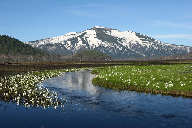
Ozegahara is a highland moor surrounded by high-mountains, including Mt. Hiuchigatake and Mt. Shibutsu (Shibutsu-san). The area has been designated as Oze National Park. It spans Gunma, Fukushima, and Niigata Prefectures. The wetland is dotted with ponds of various sizes and is home to numerous rare alpine plants. Groves of trees along the river known as "gallery forests" grow between the wetland and the mountainous backdrop, forming some memorable scenery. The route showcased here does a circuit of Ozegahara, starting from the Hatomachi-toge Pass on the Gunma Prefecture side, which has relatively good access.
Ozegahara, Round Trip from Hatomachi-toge Pass with a Loop from Ushikubi
Tour one of Japan's top highland moors.
-
- Duration
- 1Day / 6Hours
- Highest Point
- 1591m
- Elevation Gain
- 193m
-
- Skill Level


- Fitness Level
- Gear Level
From the trailhead at Hatomachi-toge Pass, go down the stairs through the forest and descend a boardwalk, and in about an hour you'll arrive at Yamanohana at the edge of Ozegahara. It has three mountain huts as well as a rest area, a visitor center, a camping area, and a toilet.
Proceed to the right from Yamanohana and follow the boardwalk through the wetland dotted with ponds among the meadows with Mt. Hiuchigatake rising before you. Cross the bridge over the Kamino-ohori River (Kamino-ohhori-gawa) and proceed with a small hill on your right. You will reach the Ushikubi junction about 45 minutes from Yamanohana.
From there go straight on the wooden path through the wetlands punctuated with groves of Erman's birch and other trees. Once you see a mountain hut in the forest down the path, you'll soon arrive at the Ryugu-jujiro junction. It's about 40 minutes from the Ushikubi junction. Take the fork to the left and continue along the wetland boardwalk with a gallery forest to your right, and you will arrive at Yoppi Suspension Bridge (Yoppi tsuri bashi) about 30 minutes from the junction.
Keep on the boardwalk to the left towards the Ushikubi junction. Don't cross the suspension bridge. Walk along the Yoppi River (Yoppi-gawa), and you will arrive back at the Ushikubi junction about 50 minutes from Yoppi Suspension Bridge.
You'll return from there to Hatomachi-toge Pass, completing the hike. Until Yamanohana enjoy the renowned Oze scenery with Mt. Shibutsu rising before you.
Gallery
Oze, round trip hike from Yamanohana.
Other Info
Ozegahara features abundant flora, and you can take in the changing scenery of the seasons including flowers and autumn foliage. Late May to mid-June sees the mizubashoh (Asian skunk cabbage) in bloom, and early to mid-July is the season for Nikkoh-kisuge (day lilies). Lots of hikers arrive to see the beautifully colored wetland grasses from the end of September through early October, as well as the foliage of the gallery forests.
High Season:June to September
Notes
There are double-tracked boardwalks along most of Ozegahara's walks. Keep to the right as you hike, and don't stray from the boardwalk into the wetland. If you bring trekking poles, be sure to use rubber tips to avoid damaging the boardwalks.
Route Map
Elevation Map
Height (m)
Horizontal Distance (km)
Spec
- Duration
- 1Day / 6Hours
- Highest Point
- 1591m(Hatomachi-toge Pass)
- Elevation Gain
- 193m
- Horizontal Distance
- 15.8Km
- Skill Level
- Fitness Level
- Gear Level
On the Trail
- Sleeping
Hatomachi Sanso, Shibutsu Sanso, Kokumin-shukusha Oze Lodge, Yamanohana-goya, Ryugu-goya
- Eating
Hatomachi-toge Rest Area
- Hot-Springs
Tokura-no-Yu, a day-use hot spring facility


