


Hotaka Peaks (Hotaka-renpo) is a series of peaks stretching from north to south in the southern region of Northern Japanese Alps, and spanning the border of Gifu and Nagano prefectures. With the highest point, Mt. Okuhotaka (Okuhotaka-dake), as the main peak, the ridge of stony summits, which also includes Mt. Kitahotaka (Kitahotaka-dake), Mt. Mae-hotaka (Maehotaka-dake), and Mt. Karasawa (Karasawa-dake), inspires and fascinates countless hikers. In this guide, we introduce a route to Mt. Okuhotaka-dake, which is not just the highest Hotaka peak, but also the highest peak in Northern Japanese Alps and the third highest in Japan. The traverse connects with many other peaks, allowing for a variety of different routes. Due to the steep ascents and descents involved in some of these routes, however, the one that we introduce here is the route beginning in the Karasawa Cirque.
Round trip hike to Mt. Okuhotaka from Kamikochi
-
- Duration
- 3Days / 13.5Hours
- Highest Point
- 3190m
- Elevation Gain
- 1690m
-
- Skill Level


- Fitness Level
- Gear Level
Walk along the paved road from the bus terminal and you will soon arrive at Kappa Bridge (Kappabashi). Rather than crossing Kappa Bridge, continue along the left bank of the Azusa-gawa River . After passing the Konashi-daira camping area, follow the footpath into the forest.
Once you have passed the Myojin area, hike up a small slope. The route now veers away from the Azusa-gawa River and turns into a level path through the forest. Then, the path once again draws close to the Azusa-gawa River. You will reach Tokusawa after about two hours of walking from central Kamikochi. The grassy fields here serve as a popular campground where rows of colorful tents are set up.
From Tokusawa, continue to follow the left bank of the Azusa-gawa River and after about an hour you will arrive at Yokoo. This segment of the trek covers roughly 11 kilometers of ground over 3 hours.
From here, cross over Yokoo Ohashi Bridge to the right bank of the Azusa-gawa River, and then follow the sloping path through the forest. On the opposite side of Yokoo Valley, you can see the Byobu-iwa Rock. Cross Hontani Bridge to reach the other side of Yokoo Valley where the slope of the path turns steep. Then follow a zigzagging path for a while. The course is well adapted to the rocky terrain and easy to walk across. Here the path becomes a traverse.
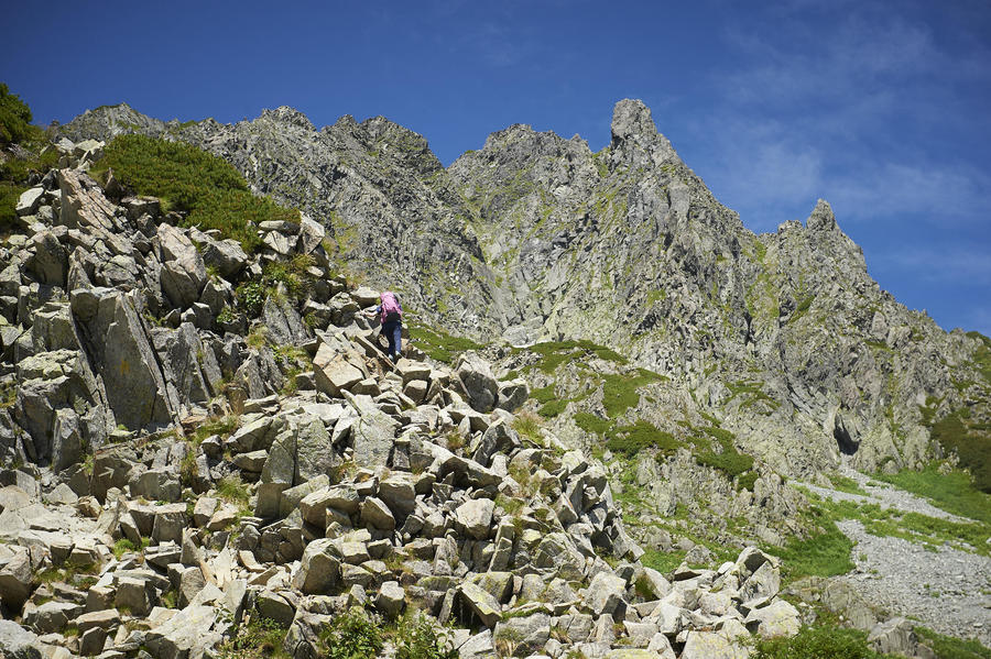
Hike up the path and pass through an area scoured by landslides. As you move through the surrounding birch and shrubbery, your view of the area will open up. From there, a rocky section continues for a while. When you reach the junction marked Karasawa Hutte/Karasawa-goya, turn left and go up the stone steps toward the Karasawa Hutte where you will spend the first night of the trek.
On the second day, start climbing the slope leading up toward the Hotaka peaks from the Karasawa Cirque. Take the route on the left of the junction at the camping area. From here there are two paths: one that zigzags up a rocky section and another that passes through the shrubbery behind the Karasawa-goya mountain hut. But there is no significant difference in the time each course takes, and you should arrive at Seitengrat within about 90 minutes.
Seitengrat is a ridge, which passes through a stone pine belt. The path branches toward the main ridge, so it turns steep at this point. As the terrain gives way to a rock face, you will encounter chains and ladders in this area. As you progress to higher altitude, the landscape around you will change to rocky sections. After about 80 minutes from Seitengrat, you will arrive at a col at the top of the ridge where Hotaka-dake Sanso mountain hut stands.
Drop off any unneeded baggage at Hotaka-dake Sanso and do a round trip climb of Mt. Okuhotaka, on the south side of the ridgeline. After leaving the hut, you will soon encounter two long and steep ladders and chains for climbing the steep rock face.
After this, hike up the broad, gently sloping rocky section. It takes about 50 minutes to reach Mt. Okuhotaka’s peak from Hotaka-dake Sanso. After a 30-minute descent, you will arrive back at Hotaka-dake Sanso where you spend the second night of the trek.
On the third day, follow the same route back in reverse to complete the round trip.
Gallery
Other Info
After returning to the Hotaka-dake Sanso on the second day, consider climbing Mt. Karasawa on the northern side of the ridge, if you have enough time and energy left and the weather isn’t bad.
At 3,110 m, it’s the eighth highest peak in Japan. It takes about 35 minutes to complete a round trip hike to the top of Mt. Karasawa and back to the Hotaka-dake Sanso.
High Season:July to early October
If you go to this trail outside of the best season, you should pay attention to weather and trail conditions, as the mountain is located in a snowy area; there may still be snow on the trail in June, and it may start snowing from October. Snow mountaineering equipements and experience are required during the winter season.
Notes
The hike from the Karasawa Cirque to the upper portions of the route includes hazards such as falling rocks and dangerous falls along the trail, so the use of a helmet is recommended. Karasawa Hutte offers helmet rentals for a fee.
Route Map
Elevation Map
Spec
- Duration
- 3Days / 13.5Hours
- Highest Point
- 3190m(Mt. Okuhotaka)
- Elevation Gain
- 1690m
- Horizontal Distance
- 37.3Km
- Skill Level
- Fitness Level
- Gear Level
On the Trail
- Sleeping
Myojin Kan, Tokusawa Lodge, Tokusawa-en, Yokoo Sanso, Karasawa Hutte, Karasawa-goya, Hotaka-dake Sanso
- Eating
At the starting and ending point of the hike, there is a restaurant called Kamikochi Shokudo on the second floor of the Kamikochi Bus Terminal building. You can also purchase food from the dining halls of all mountain huts.
- Hot-Springs
Konashi no Yu


