


Mt. Gassan is located in the central part of Yamagata prefecture in the Tohoku Region, north-eastern Japan. Located in the Bandai-Asahi National Park, the mountain is one of Japan’s 100 most famous mountains. Along with neighboring Mt.Yudono (Yudono-san) and Mt. Haguro (Haguro-san), it constitutes the Three Mountains of Dewa (Dewa Sanzan). The mountain has been the object of religious faith and Gassan-jinja Shrine is built at the peak. To this day, many hikers visit to worship. This route introduces a round trip starting from Ubasawa located on the south side, partially going along the ridgeline.
Mt. Gassan: Round Trip from Ubasawa
One-day hike to the peak of a sacred mountain amidst flowers of the Tohoku Region.
-
- Duration
- 1Day / 6.5Hours
- Highest Point
- 1984m
- Elevation Gain
- 825m
-
- Skill Level


- Fitness Level
- Gear Level
Ubasawa trailhead is equipped with parking, toilets, a restaurant and Japanese-style hotel. Entrance to the trail is located behind Ubasawa-goya mountain hut.
Proceeding through the forest along the wooden walkway and hiking up a rocky section in the grassy plain, you will find multiple springs spilling water onto the trail.
Continue hiking up the wooden walkway in the grassy plain for about 2 hours from the trailhead, you will reach the Lower Ushikubi Junction (Ushikubishita Bunki).
Take the trail on the right and hike up the steep stone-paved path. Ushikubi is about 30 minutes away. You can reach the summit of Mt. Gassan from Ushikubi in about an hour walking through a grassy plain, pine grove and up stone steps. A shrine and lodge is located at the top.
The descending route goes by way of Mt. Ubagatake. Taking the same route down to Ushikubi and proceeding straight along the ridgeline, you will reach the col named Kanauba, an hour and 10 minutes away from the summit.
Hiking up from Kanauba and proceeding along a gently sloping wooden walkway on the ridgeline, Mt. Ubagatake is about 20 minutes away. Descending the steep stone paved path from Mt. Ubagatake for about 20 minutes will take you to the Lift-Ue Station. Proceed on the stone pavement traversing the slope through a grassy plain for about 30 minutes, you will return to the Lower Ushikubi Junction.
From the Lower Ushikubi Junction, descend on the same trail to the end.
Gallery
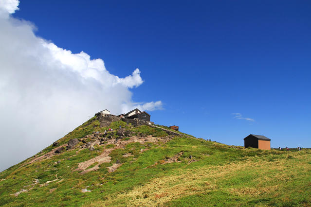
Gassan-jinja Shrine at the summit
Other Info
Mt. Gassan is also famous as the home of flowers. In July and August, various alpine flora bloom along the ridgeline from Ushikubi to the summit.
It is also a sacred mountain. You may encounter worshipers in white clothing on the way.
High Season:July to September
Notes
Mt. Gassan receives heavy snowfall, allowing visitors to enjoy skiing even during the summer on some of the slopes.
From the vicinity of Ushikubi Junction up to the ridgeline, snow sometimes remains even in the latter half of July. Depending on conditions mini crampons may be necessary.
Route Map
Elevation Map
Height (m)
Horizontal Distance (km)
Spec
- Duration
- 1Day / 6.5Hours
- Highest Point
- 1984m(Mt. Gassan )
- Elevation Gain
- 825m
- Horizontal Distance
- 11.8Km
- Skill Level
- Fitness Level
- Gear Level
On the Trail
- Sleeping
Gassan Chojo-goya
- Eating
Ubasawa Praking Area
- Hot-Springs
Gassan Shizu Onsen


