


The Kuju Mountain Range is located in Aso-Kuju National Park in Kyushu's Oita Prefecture. The magnificent volcanic group consists of roughly a dozen peaks and is among Japan's top 100 mountains. It's divided into Kuju mountain system (Kuju-sankei) in the western area and Daisen mountain system (Daisen-sankei) in the eastern area.
The route we showcase here tours Tadewara and Bogatsuru (Bohgatsuru) wetlands. Both are registered with the Ramsar Convention, an international agreement that protects wetland ecosystems. The hike also takes in Mt. Daisen (Daisen-zan) with its mountain-top lake and Mt. Hiji-dake, which has lovely springtime Miyamakirishima (Rhododendron kiusianum).
Kuju Mountain Range: Bohgatsuru, Mt. Daisen, and Mt. Hiji-dake Circuit
The Best Wetland and Mountain Views in the Kuju Mountain Range.
-
- Duration
- 1Day / 8Hours
- Highest Point
- 1786m
- Elevation Gain
- 756m
-
- Skill Level


- Fitness Level
- Gear Level
From Chojabaru, follow the level boardwalk through Tadewara-shitsugen. You'll reach a broadleaf forest, and in about 70 minutes Amagaikegoshi.
Descending slowly from Amagaikegoshi, you'll reach Bohgatsuru in about 40 minutes. The wetland of Bohgatsuru fills a basin between Mt. Kuju and Mt. Daisen. To help conserve the wetland vegetation, burns are held every year from late March to early April.
Take the fork to the right after passing a camping area and zigzag up the slope until you reach the ridgeline. As you walk along the ridgeline with the crater wall to the right, you'll arrive at Mt. Daisen. It's an hour and 40 minutes from Bohgatsuru. The crater lake called Oike Pond is directly below the summit. It's a popular photo spot when the foliage turns color in October.
Return to the junction and descend the slope from the ridgeline. Ascending from the col at Otogoshi (Ohtogoshi), also called Utongoshi, you'll arrive at Mt. Hiji-dake. It's about 1.5 hours from Mt. Daisen.
Descending from Mt. Hiji-dake via Otogoshi, you'll return to Bogatsuru in approximately 70 minutes. From there make your way back to Chojabaru (Chohja-baru) along the same route you came.
Gallery
Other Info
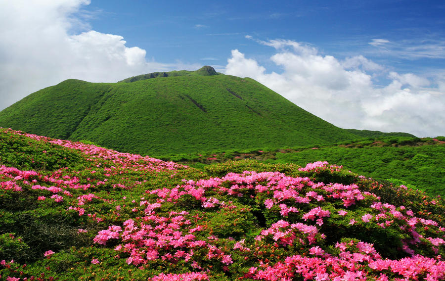
Miyamakirishima only grows in the high mountains of Kyushu, and it’s found throughout the Kuju Mountain Range.
The large colony of it that covers the area including Mt. Daisen and Mt. Hiji-dake has been designated one of Japan's Natural Monuments. The flowering season is from the end of May to the beginning of June.
High Season:April to June, October to November
Notes
This route is presented as a day trip, but spending a night in the mountains comes recommended, too. Besides camping at Bogatsuru, you can soak in a secluded hot spring deep in the mountains at Hokkein Onsen Sanso mountain hut about 15 minutes away. Either of these make good bases for hiking Daisen and the Kuju mountain systems or traversing them in a single trip.
Route Map
Elevation Map
Height (m)
Horizontal Distance (km)
Spec
- Duration
- 1Day / 8Hours
- Highest Point
- 1786m(Mt. Daisen)
- Elevation Gain
- 756m
- Horizontal Distance
- 15.8Km
- Skill Level
- Fitness Level
- Gear Level
On the Trail
- Sleeping
Asebi-koya, Hokkein Onsen Sanso
- Eating
Chojabaru Health Center
- Hot-Springs
Chojabaru Health Center


