


Mt. Tsukuba (Tsukuba-san) is located in central Ibaraki Prefecture in the Kanto region, and is a twin-peaked mountain consisting of Mt. Nantai (Nantai-san) and Mt. Nyotai (Nyotai-san). It is one of the most well-known mountains in the Kanto area that has been admired from olden times as “Tsukuba of the east, Fuji of the west,” and has appeared in many Japanese waka poems. Along with Tsukubasan-jinja Shrine that stands on the southern foothill, each of the peaks is home to shrine buildings that enshrine the deities of the shrine, making the entire mountain a divine zone.
This course introduces the circulating route, which starts from Tsukubasan-jinja Shrine, hikes up the Miyukigahara course heading for the col between the two peaks and descends the Hakuunkyo course, interspersed with strangely shaped rocks.
Circulating Route on Mt. Tsukuba from Tukubasan-jinja Shrine
-
- Duration
- 1Day / 4.5Hours
- Highest Point
- 877m
- Elevation Gain
- 663m
-
- Skill Level


- Fitness Level
- Gear Level
From Tsukuba-san jinja iriguchi bus stop, walk through the grounds of Tsukubasan-jinja Shrine via the hot spring town for approximately 15 minutes. Hikers will arrive at the trailhead with a torii gate. Hike up the staircases among the cedar forest and past the open space along the cable car railway, the trail turns into rocky section that has ladders and ropes. It takes approximately 70 minutes to get to the source of the Minano-gawa River. Proceed zigzagging up on the steep slope and hike up the long staircase for approximately 30 minutes, and hikers will arrive at Miyukigahara.
Miyukigahara is an open space where the Sancho Station of the cable car line is located, offering stores, restaurants and a cafe, and o a great view.
From Miyukigahara, Mt Nantai is approximately 20 minutes round-trip up through the staircases and rocky sections.
Approximately 20 minutes of gentle ascending from Miyukigahara via giant rocks such as Sekirei-ishi and Gama-ishi will take hikers to Mt. Nyotai.
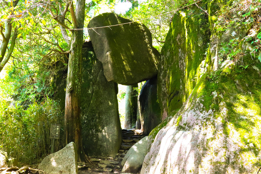
With the view of giant rocks such as Daibutsu-iwa, Byobu-iwa, Hokuto-iwa and Hahano-tainaikuguri, descend the partially chain-supported rocky section, and after passing under another giant rock named Benkei-nanamodori, hikers will arrive at the fork where Benkei-chaya used to be, in approximately 40 minutes.
Proceed southwestward, descend the partially stone-paved slope and through Tsukubasan-jinja Shrine. Hikers will return to Tsukuba-san jinja iriguchi bus stop in approximately 75 minutes.
Gallery
Other Info
Since Mt. Tsukuba stands distinguished on the northeastern part of the Kanto Plain, its summit is utilized as a meteorological station and has multiple antennas for radio communication. The mountain can be easily identified from the wide area on the southwest side by its twin peaks and antennas. Mt. Tsukuba is visible from Tokyo Bay on a sunny day. It may be fun to look for the mountain from the city after hiking it.
High Season:November to May
Notes
Mt. Tsukuba has a cable car line, from Miyukigahara on Mt. Nantai to Miyawaki near the Tsukubasan-jinja Shrine on the southern foothill, and a ropeway line from Mt. Nyotai summit to Tsutsujigaoka located on the eastern hillside. Utilize them according to the weather and your health conditions.
Route Map
Elevation Map
Spec
- Duration
- 1Day / 4.5Hours
- Highest Point
- 877m(Mt. Tsukuba / Mt. Nyotai)
- Elevation Gain
- 663m
- Horizontal Distance
- 6.9Km
- Skill Level
- Fitness Level
- Gear Level
On the Trail
- Sleeping
- -----
- Eating
Koma Observatory
- Hot-Springs
Tsukubasan Onsen


