


The Tanigawa Mountain Range (Tanigawa-renpo) is on the border of Gunma and Niigata prefectures. Its many peaks include Mt. Ichinokura (Ichinokura-dake), Mt. Shigekura (Shigekura-dake), and Mt. Tanigawa (Tanigawa-dake), one of Japan's 100 most famous mountains. While there are day hikes you can do too, here we showcase a two-day traverse. It starts from Mt. Tanigawa, follows the ridgeline along the border of Gunma and Niigata prefectures, and circles the ridgeline to the east of the Yubiso-gawa River clockwise.
Mt. Tanigawa Horseshoe Trail Traverse
Long-distance traverse of the Tanigawa Mountain Range.
-
- Duration
- 2Days / 14.5Hours
- Highest Point
- 1978m
- Elevation Gain
- 1316m
-
- Skill Level


- Fitness Level
- Gear Level
Get to Tenjin-toge Pass via the Tanigawadake Ropeway and the tourist lift. From there hike along the ridgeline of a shrub zone, and then descend into a beech forest. When you merge with the road from Tenjin-daira, you will hike up a gentle boardwalk. After traversing a rocky area, you'll arrive at Kumaanazawa-hinan-goya shelter hut. It's about 45 minutes from Tenjin-toge Pass. Ascend the scree slope through a shrub zone, and after passing through an area with chains, you'll reach a level ridgeline with a boardwalk.
Go over a rocky area and pass a huge rock outcrop called "Tengu-no-tamariba." Ascend a ridgeline through a bamboo grass field, proceed along the boardwalk, and you'll reach Tanigawadake-katano-koya mountain hut. Continue to ascend and you'll arrive at the first of Mt. Tanigawa's twin peaks, Toma-no-mimi. It's about an hour and 30 minutes from Kumaanazawa-hinan-goya.
The other peak, Oki-no-mimi, is about 10 more minutes down the trail. Proceed from there along a ridge with the sheer cliffs of Ichinokura-sawa to the right and you'll arrive at Mt. Ichinokura. It's about 50 minutes from Oki-no-mimi. Continue along the grassy ridgeline for about 20 minutes to reach Mt. Shigekura, the highest peak on this route. Take the fork to the right at the trail junction.
After descending about 400 meters and then hiking up a steep slope, you'll reach Mt.Buno-dake. It's about an hour 40 minutes from Mt. Shigekura. Another roughly 40-minute descent through grassland will bring you to Yomogi-toge Pass at a col in the mountains. You'll spend the night there at Yomogi Hutte.
On the second day, first you'll set out for Mt. Nanatsugoya (Nanatsugoya-yama). After passing over a small peak, continue along a boardwalk. Ascend again and you'll arrive at Mt. Nanatsugoya. It's about an hour and 10 minutes from Yomogi-toge Pass.
Descend through a bamboo grass field for about 50 minutes and you'll reach Shimizu-toge Pass with its shelter hut. From there it's a steep roughly 500-meter ascent that in about 2 hours brings you to Junction Peak. After another roughly 30 minutes along through a gently sloping grassland you'll arrive at Mt. Asahi (Asahi-dake).
Continuing on you'll ascend and descend peaks of various sizes before reaching Mt. Kasagatake in about an hour. After another roughly 50 minutes you'll arrive at Mt. Shiragamon. From there you descend 1,000 meters for a bit over 2 hours.
Enter the forest from the rocky ridgeline and you'll cross a stream once the descent ends before reaching a paved road. Proceed down the paved road for about 10 minutes and you will arrive at Doai Station.
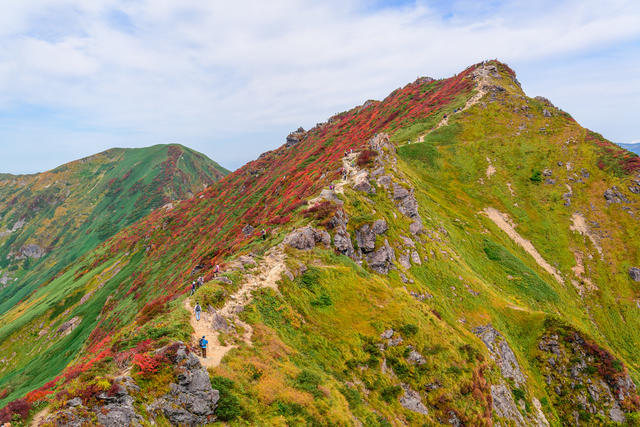
Gallery
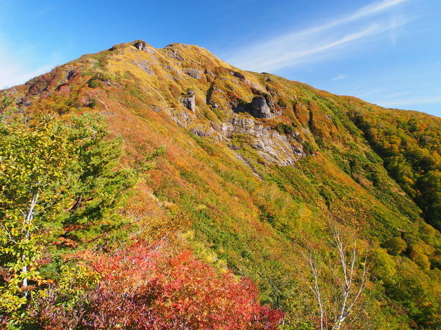
Vibrant autumn foliage on Mt. Shirogamon.
Other Info
In the 16th century, Yomogi-toge Pass and Shimizu-toge Pass were key transit points along roads connecting Gunma and Niigata prefectures. Peddlers with goods as well as military commanders and their troops regularly passed back and forth along these routes. In the 17th century, with the establishment of the Mikuni-kaido Avenue, the Shogunate banned travel over them. Nonetheless, some still used them covertly. Hiking with an understanding of this history makes it even more interesting.
High Season:June to October
Notes
This is an extended traverse with a large difference in elevation. From Yomogi-toge Pass it takes about 3 hours 30 minutes to reach Doai Station walking the Shindo Road along the Yubiso-gawa River via the Shirakaba-hinan-goya shelter hut. From Shimizu-toge Pass you can reach Doai Station in about 4 hours 30 minutes. First walk the former national road, then when you reach the Shirakaba-hinan-goya, continue down the same route just mentioned.
If the weather turns bad or you find you've underestimated the physical requirements of the hike, you can cut it short by descending to Doai Station via one of these routes.
Route Map
Elevation Map
Height (m)
Horizontal Distance (km)
Spec
- Duration
- 2Days / 14.5Hours
- Highest Point
- 1978m(Mt. Shigekura)
- Elevation Gain
- 1316m
- Horizontal Distance
- 25.1Km
- Skill Level
- Fitness Level
- Gear Level
On the Trail
- Sleeping
Kumaanazawa-hinan-goya, Tanigawadake-katano-koya, Ichinokura-hinan-goya, Yomogi Hutte, Shirakuzure-hinan-goya, Kasagatake-hinan-goya, Doaiyama-no-ie
- Eating
View Terrace Tenjin Restaurant
- Hot-Springs
Yu Terume Tanigawa


