


Mt. Kinpu (Kinpu-san) and Mt. Mizugaki (Mizugaki-yama) are located on the border between Yamanashi Prefecture and Nagano Prefecture in the western part of the Okuchichibu Mountain Range. Both of the mountains, each with its own unique charms, are counted among Japan’s 100 most famous mountains. Mt. Kinpu, a sacred mountain, has a gently-sloping shape and is topped with a massive boulder called Gojo-iwa rock at its peak. Meanwhile, Mt. Mizugaki bristles with massive, unusually-shaped boulders and its base has become a major destination for rock climbing. Here we will introduce and out-and-back route to both mountains that uses the Fujimi-daira plateau located between them as a base camp.
Round Trips to Mt. Kinpu and Mt. Mizugaki from Fujimi-daira
Summit two famous peaks of the Okuchichibu Mountains in the style of base camp!
-
- Duration
- 2Days / 11Hours
- Highest Point
- 2599m
- Elevation Gain
- 1084m
-
- Skill Level


- Fitness Level
- Gear Level
From the Mizugaki-sanso mountain hut located at the trailhead, hike up the gentle slope through the forest belt. After coming out onto a ridge where you can see the shape of Mt. Mizugaki and proceeding further you will arrive at the Fujimidaira-goya mountain hut in about 50 minutes after leaving the Mizugaki-sanso. There is a campsite here and also a watering hole located immediately below the mountain hut. Leave any excess equipment here before heading for Mt. Mizugaki on the first day.
From the left side of the mountain hut, proceed through the mossy forest belt and hike down the slope. You will arrive at the riverbed of the Amadori-gawa River in about 30 minutes where you will then cross the river. The trail to Mt. Mizugaki starts here. Pass the stairs on the side of Momotaro-iwa rock and hike up through the conifer forest belt and the azuma shakunage (Rhododendron metternichii) and you will eventually come to a steep slope dotted with rocks of various sizes. You will gradually gain altitude as you pass between rocks and through rocky areas with chains.
As you climb up while looking at a rock tower called Ohyasuri-iwa the trail will transition into a traverse of the north face of the summit. There are ladders and chains on the steep slope just below the summit. You will arrive at Mt. Mizugaki about 2 hours after leaving the Fujimidaira-goya. The summit is a rocky area that projects out of a forest. It offers good views of the Yatsugatake Volcanic Group, Mt. Kinpu, and beyond.
Take the same route back down to the base camp. You will arrive at the Fujimidaira-goya in about one and a half hours. You will stay the first night here.
On the second day, you will head for Mt. Kinpu. Hike up the ridge through the conifer forest belt before traversing Mt. Meshimori (Meshimori-yama). You will arrive at the unmanned Dainichi-goya mountain hut in about an hour and then at Dainichi-iwa rock in about another 30 minutes.
From Dainichi-iwa rock, the trail proceeds along a ridge line with a good view. After going over several peaks, and traversing through a stone pine belt you will arrive at the summit of Mt. Kinpu about an hour and 50 minutes from Dainichi-iwa rock. The summit is a broad rocky area topped by the massive Gojo-iwa rock, upon which a red shrine gate stands.
Take the same route back down to the base camp. You will arrive at the Fujimidaira-goya in about 2 and a half hours and at the Mizugaki-sanso in about another 40 minutes.
Gallery
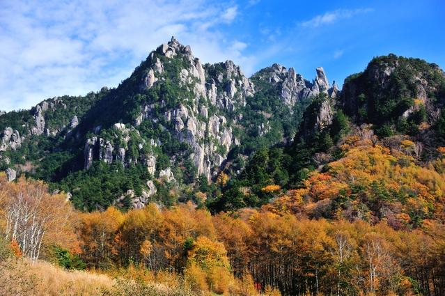
The yellow autumn foliage of Japanese larch trees on Mt. Mizugaki.
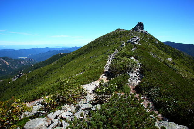
A view from Mt. Kinpu of the adjoining ridge.
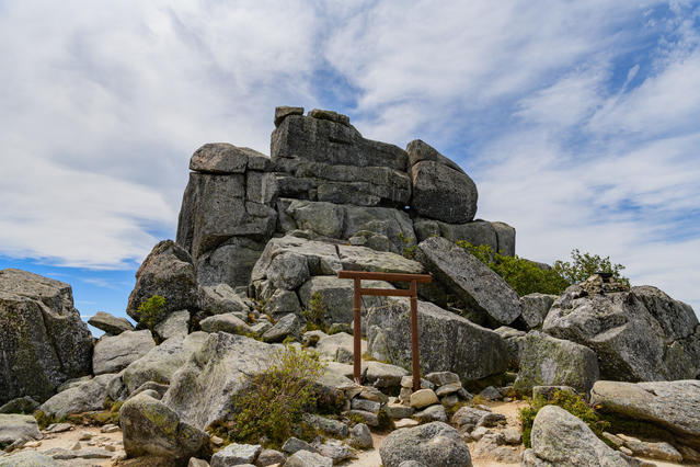
The Gojo-iwa rock, a symbol of Mt. Kinpu.
Other Info
In recent years, Mt. Mizugaki has become a popular destination for rock climbing for climbers from all around the world. Mizugaki-yama Natural Park, which has a campground and a large parking lot, offers convenient access to climbs such as Kanmanboron, Ohzura-iwa rock, Kozura-iwa rock, and Toichimen-iwa (or Juichimen-iwa) rock. Although there are a number of small boulders which can the free climbed, each requires sufficient equipment and skill.
High Season:May to November
Notes
This route makes out-and-back trips to both mountains from Fujimidaira, which it uses as a base camp. Fujimidaira is located about one kilometer from the Mizugaki-sanso trailhead. We recommend that you prepare your hiking equipment and the equipment you will need for staying overnight at the base camp in a matter that allows it to be separated. This will allow you to travel lighter when hiking to each mountain.
Route Map
Elevation Map
Height (m)
Horizontal Distance (km)
Spec
- Duration
- 2Days / 11Hours
- Highest Point
- 2599m(Mt. Kinpu)
- Elevation Gain
- 1084m
- Horizontal Distance
- 13.5Km
- Skill Level
- Fitness Level
- Gear Level
On the Trail
- Sleeping
Mizugaki-sanso, Fujimidaira-goya, Dainichi-goya, Kinpusan-goya
- Eating
Mizugaki-sanso
- Hot-Springs
Masutominoyu


