


Japan’s Own Long Trail: A 50 km Route Traversing Mt. Iwate, the Mt. Hachimantai, and Appi Highlands
-
- Duration
- 3Days / 21Hours
- Highest Point
- 2038m
- Elevation Gain
- 1469m
-
- Skill Level


- Fitness Level
- Gear Level
After getting off the Appi Gondola, hike down from the peak of Mt. Maemori for about 30 minutes to the junction below, then follow the path through a forest belt. You can walk to the peaks of Mt. Nishimori (Nishimori-yama) and Mt. Yanomune (Yanomune-dake) and back to the path in around 10 minutes.
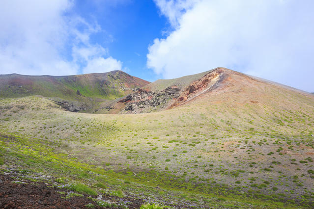
It takes about 2 hours and 15 minutes to reach Mt. Daikokumori after setting out from Mt. Maemori. From Mt. Daikokumori, continue on past the peak of Mt. Ebisumori and hike up the gentle slope on the other side to reach the Chausu-sanso mountain hut (approx. 45 minutes). From here, you can hike to Mt. Chausu (Chausu-dake) and back in about 20 minutes.
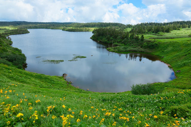
From the mountain hut, ease your way down the trail to arrive at a wooden walkway that passes through a marshy patch and leads to the Kuroyachi wetland with its smattering of peat bogs. During July and August, you can see fields of alpine flora in this area. From the Kuroyachi wetland, hike up the slope to Gentamori and then descend the trail toward Hachiman-numa Pond. After about an hour and 15 minutes, you will arrive at the peak of Mt. Hachimantai where you will find an observatory.
Hike down from the peak for about 30 minutes to reach the Hachimantai trailhead where you wll find a bus terminal and rest house. The first day of the hike ends here. Due to the fact that the following night will be spent in a shelter, you will want to get a good rest at a nearby accommodation like Toshichi Onsen or Hachimantai Onsen Kyo (Hachimantai Hot-spring Village).
On following day, begin your hike anew at the Hachimantai trailhead. Walk along the paved road of the Hachimantai Jukai Line until you reach the Mokkodake trailhead. Then, hike up through the conifer belt to the junction. From here, you can hike to the scenic peak of Mt. Mokko (Mokko-dake) and back in about 10 minutes.
From the junction, hike up an over the small peak and continue down the gentle slope to reach Mt. Morobi (Morobi-dake). Then, hike down through a conifer belt until you reach the shore of the Ishinuma marsh. Continue on past Mt. Maemorobi (Maemorobi-dake) until you reach Mt. Kensomori.
Hike along the ridgeline while admiring the view of Kagaminuma pond below. After about an hour of hiking from Mt. Kensomori, you will arrive at the Obuka-sanso shelter hut. From the Obuka-sanso mountain hut, hike for 30 minutes to the peak of Mt. Obuka (Obuka-dake) and hike up for a further 50 minutes to the peak of Mt. Komokko (Komokko-yama). Continue on past the Mitsunuma peat bog and hike up to Mt. Mitsuishi. Here, among stone pines and scattered boulders, beautiful autumn foliage can be seen in late September.
From Mt. Mitsuishi, hike down the trail for about 20 minutes to reach the Mitsuishi wetland. Here, you will find the Mitsuishi-sanso shelter hut where you will spend the second night of the trek. On the third day of the trek, set out from Mitsuishi-sanso and hike up and over Mt. Omatsukura (Omatsukura-yama) and continue along a forested segment of trail to reach the Inukura junction.
Traverse the slopes of Mt. Inukura (Inukura-yama) and Mt. Kurokura (Kurokura-yama) without ascending the peaks and within about an hour you will reach Ojigoku junction at a cut in the rocky terrain.
From here, hike up a steep, rocky ridge to the left for about 2 hours to Fudodaira with its shelter. Hike back up toward the Mt. Iwate ridgeline and follow the path that winds around the caldera clockwisely. After about an hour, you will arrive at Mt. Yakushi (Yakushi-dake), which is the highest point on Mt. Iwate.
Swing back by the caldera and continue northwest down a loose gravel slope toward the Hirakasafudo-hinan-goya shelter hut before traversing downward through a stone pine belt. Take the right turnoff at the Tsuruhashi junction and hike down to the Yakehashiri Course. Hike down the gravel slope for another 40 minutes and continue past the Daini Funshutsuko-ato.
After about an hour of hiking down through a forest belt, you will reach the Yakehashiri trailhead where your long trek concludes.
Gallery
Other Info
It is recommended that you spend the first night of the trek at the Toshichi Onsen. A free shuttle service runs from the Hachimantai trailhead bus stop, and it is also near the Mokkodake trailhead where you start the second day of the trek.
High Season:July to early October
Notes
The Mitsuishi-sanso shelter hut where you will spend the second night of the trek is an unstaffed shelter. You must bring your own sleeping bags and other necessities as well as gear needed to prepare food to facilitate a comfortable stay.
Route Map
Elevation Map
Spec
- Duration
- 3Days / 21Hours
- Highest Point
- 2038m(Mt. Iwate, Mt. Yakushi)
- Elevation Gain
- 1469m
- Horizontal Distance
- 48.3Km
- Skill Level
- Fitness Level
- Gear Level
On the Trail
- Sleeping
Chausu-sanso, Ryoun-so, Ofuka-sanso, Fudodaira-hinan-goya, Hirakasafudo-hinan-goya
- Eating
Iwate Yakehashiri International Exchange Village
- Hot-Springs
Iwate Yakehashiri International Exchange Village


