


Mt. Kitadake is both the highest peak in the Southern Japanese Alps and (at 3,193 m) the second highest peak in Japan after Mt. Fuji (Fuji-san). Along with Japan’s third highest peak, Mt. Ainodake (at 3,190 m) and Mt. Notori (Nohtori-dake), the traverse is known as Shirane Sanzan (Shirane three peaks), whose peaks can be seen from the Kofu Basin. Here, we introduce a route which extends from north to south, traversing the three major peaks in the range and which offers spectacular views of Japan’s highest peak, Mt. Fuji.
The Southern Japanese Alps: a Traverse of Mt. Kitadake, Mt. Ainodake, and Mt. Notori
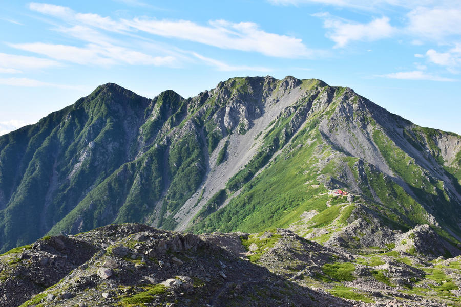
The alpine traverse with Japan’s second and third highest peaks.
-
- Duration
- 3Days / 18.5Hours
- Highest Point
- 3193m
- Elevation Gain
- 2373m
-
- Skill Level


- Fitness Level
- Gear Level
After getting off the bus at Hirogawara (Trailhead), cross the suspension bridge and hike through the coniferous trees of the old growth forest. Here, the path turns into a traverse. Cross a small stream and continue to the Shirane-oike-goya mountain hut, located about 2 hours and 35 minutes from Hirogawara.
Turn right at the Futamata junction and hike up Kusa-suberi where the gradient begins to get steep (“Kusa-suberi” means the slippery grassy slope in Japanse) . Follow a zigzagging path through the grassy area until the grass gives way to shrubbery. From Shirane-oike it takes about 2 hours and 30 minutes to reach the Kotaro-one junction, where you emerge into a ridgeline.
Cross the rocky section of the ridgeline and use the chains to negotiate the next area. From the Kotaro-one junction, it takes about 30 minutes to reach the Kitadake-Katano-koya mountain hut, where you spend the first night of the trek.
On the second day, follow a zigzagging path up a rocky section passing through a stone pine belt. Go straight at the Ryoumata-goya mountain hut junction and hike further up the rocky slopes. It takes about 50 minutes to reach Mt. Kitadake from Kitadake-Katano-koya mountain hut.
From Mt. Kitadake, proceed straight ahead through the ikeyama-tsuri-one junction and hike about an hour downward along the ridgeline and into to the col where Kitadake Sanso mountain hut is located. From here, hike up the rocky section for about 40 minutes to reach Mt. Nakashirane (Nakashirane-san ). Then traverse the gentle slopes along the right hand side of the ridgeline. From Kitadake Sanso, it takes about 1 hour and 40 minutes to reach Mt. Ainodake’s peak.
Descend the broad ridgeline from Mt. Ainodake and traverse the small peak below. After about an hour, you will reach the Nohtori-goya mountain hut where you spend the second night of the trek.
On the third day, hike up the rocky sections through another stone pine belt for about 70 minutes to reach Mt. Nishi-notori (Nishi-nohtori-dake) and traverse the right side of the ridgeline for a further 50 minutes to reach Mt. Notori.
Follow the trail down from Mt. Notori for about 40 minutes and get off the ridgeline at the Daimonzawa descent point. Descend the steep rocky section along a zigzagging path and into a forest area. From the Daimon-zawa descent point to the Daimonzawa-goya mountain hut takes about 2 hours and 30 minutes. From Daimonzawa-goya, hike along the stream of the Daimon-zawa for a while until the path turns away from the stream and into a forested area.
Hike down through the trees across the traverse and after about an hour and 40 minutes, you will find a large stream, which converges into a single stream with Daimon-zawa. You will cross the stream several times as you descend along the right and left banks. After about 50 minutes, you will reach the Daimon-zawa trailhead.
From here, walk along the forest path for about 30 minutes, passing through a gate before arriving at the Narada Daiichi Power Plant. Then, follow the paved road of the Minami Alps Koen Road for about 30 minutes to reach Narada.
Gallery
Other Info
Mt. Kitadake is home to a unique species of plant called Kitadakeso (Callianthemum hondoense), now designated as endangered. The plant sprouts small white blossoms from late June to early July, which is earlier than other species of alpine flora. Although it blooms during a rainy period, the plant attracts many hikers wishing to see it.
Notes
While this route is popular for its scenic ridgeline walking, caution is necessary during the peak hiking period from July to August when lightning strikes pose a threat. Due to the long periods spent walking, you should begin your hike as soon as possible so that you are off the trails by the afternoon when thunder clouds tend to appear. It also desirable to plan your hike in a way that allows you to descend beneath the treeline early in the day.
Best Season:July to September
If you go to this trail outside of the best season, you should pay attention to weather and trail conditions, as the mountain is located in a snowy area; there may still be snow on the trail in July, and it may start snowing from October. Snow mountaineering equipements and experience are required during the winter season.
Route Map
Elevation Map
Height (m)
Horizontal Distance (km)
Spec
- Duration
- 3Days / 18.5Hours
- Highest Point
- 3193m(Mt. Kitadake)
- Elevation Gain
- 2373m
- Horizontal Distance
- 23.8Km
- Skill Level
- Fitness Level
- Gear Level
On the Trail
- Sleeping
Hirogawara Sanso, Shiraneoike-goya, Kitadake-katano-koya, Kitadake Sanso, Notori-goya, Daimonzawa-goya
- Eating
Narada-no-Sato
- Hot-Springs
Narada Onsen


