


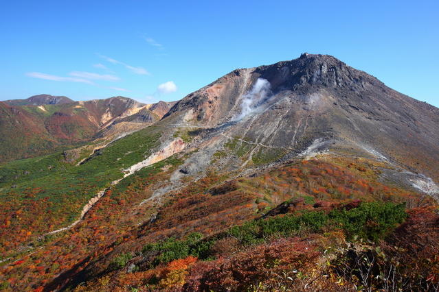
Mt. Nasu (Nasu-dake) is a stratovolcano with gently sloping terrain that extends to the Nasu Highlands (Nasu Kohgen). The term "Mt. Nasu" comprises Mt. Chausu (Chausu-dake), Mt. Asahi (Asahi-dake), and Mt. Sanbonyari (Sanbonyari-dake), as well as Mt. Minami-gassan and Mt. Kurooya (Kurooya-dake). Together, they make up the "Nasu-go-gaku (five peaks of Nasu)." Smoke currently rises from Mt. Chausu due to ongoing volcanic activity. Here we showcase a circuit hike that ascends Mt. Chausu via the ropeway and traverses the rock ridge of Mt. Asahi.
Nasu Circuit of Mt. Chausu and Mt. Asahi
A loop taking in two of Mt. Nasu's best-known peaks.
-
- Duration
- 1Day / 3.5Hours
- Highest Point
- 1915m
- Elevation Gain
- 529m
-
- Skill Level


- Fitness Level
- Gear Level
From Ropeway Sancho Station, follow the trail over rocky section until you reach the Ushigakubi junction. Proceed to the right and continue up the trail with cover ranging from pebbles to scree. Pass through the small torii shrine gate and you will arrive at the summit of Mt. Chausu. It's about 40 minutes from Ropeway Sancho Station. On the summit you'll find the small Nasudake-jinja Shrine.
From there you can circle the summit where the crater wall once stood. Descend the scree slope for about 20 minutes and you'll reach Mine-no-chaya-ato shelter hut that doesn't offer goods or services.
From there you begin the ascent of Mt. Asahi. Traverse the rocky peak of Kengamine and you'll arrive at a reddish-brown rocky ridge.There are several places with chains along the way, so be careful as you proceed.
About 40 minutes after leaving Mine-no-Chaya-ato, you will reach a fork that leads to Mt. Asahi with a bench beside it. From there, you can do a round trip to the summit of Mt. Asahi in about 15 minutes.
Returning to Mine-no-Chaya-ato takes about 30 minutes. Once you reach it, you descend the slope through rock pine and shrub, and after following a forestry road for about 40 minutes, you will arrive at Ropeway Sanroku Station.
Gallery
Other Info
As you descend between Mine-no-Chaya-ato and Ropeway Sanroku Station, Mt. Asahi is visible on the left. In early October its foliage is beautiful. Another hiking option is Ubaga-daira, accessible by taking the path on the left at the Ushigakubi fork. The fall scenery of Mt. Chausu and the foliage reflected in the pond is lovely. A round trip hike to it takes about one and a half hours from Ropeway Sancho Station.
High Season:May to October
Notes
Mt. Chausu is an ongoing active volcano with a fumarole west of the summit. Be aware that you may encounter volcanic gas when the trail is downwind. Mt. Asahi's rock ridge is not very difficult, but it is slippery when wet. Proceed with care when it rains.
Route Map
Elevation Map
Height (m)
Horizontal Distance (km)
Spec
- Duration
- 1Day / 3.5Hours
- Highest Point
- 1915m(Mt. Chausu)
- Elevation Gain
- 529m
- Horizontal Distance
- 7Km
- Skill Level
- Fitness Level
- Gear Level
On the Trail
- Sleeping
Nasudake-hinan-goya, Mineno-chaya-ato-hinan-goya
- Eating
Ropeway Sancho Station
- Hot-Springs
Gensen Nasuzan


