


A Loop Course to Mt. Ibuki from Sky Terrace
-
- Duration
- 1Day / 1.5Hours
- Highest Point
- 1377m
- Elevation Gain
- 117m
-
- Skill Level


- Fitness Level
- Gear Level
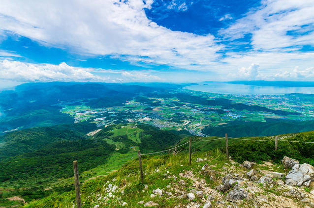
From the Sky Terrace parking lot, set out for a round trip hike to the peak via the Nishi (west) trail. From the gravel-covered hiking trail, you can also enjoy views of Japan’s largest lake, Lake Biwa-ko. From the Sky Terrace parking lot, it’s about a 40 minute walk to the mountaintop. At the peak, you will find a statue of the legendary Japanese Prince, Yamato Takeru, as well as a mountain hut, toilets, and other facilities. For the return hike, follow the descent-only path to the Higashi (east) trail and make your way back to the parking lot.
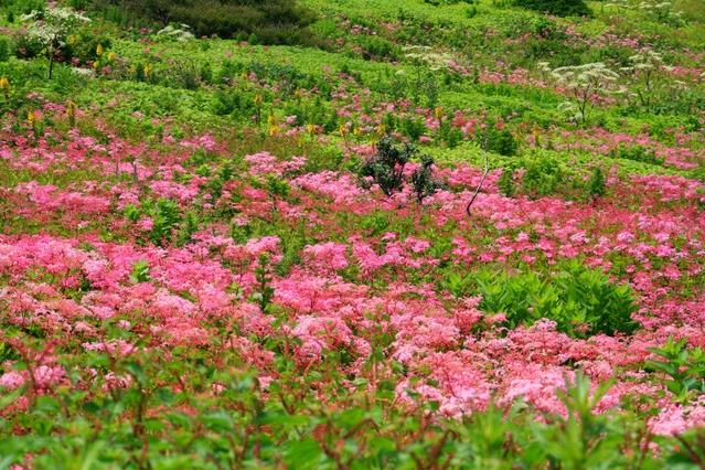
The hike begins along a gently sloping path of red clay soil, but in time you will begin to see a series of limestone rock faces. The level path gradually gives way to a slope before you come to some steep wooden stairs. After about an hour of walking from the peak, you will arrive at Sky Terrace parking lot. A variety of alpine flora blooms from July to August to turn the grasslands around the trail into flowery meadows.
The “Plant Communities of Mt. Ibuki’s Peak” have been officially designated a National Natural Monument. Several of the plant species endemic to Mt. Ibuki bear the mountain’s name, including: Ibukijakoso (Thymus quinquecostatus), Ibukireijinso (Aconitum chrysopilum), and Ibukiazumi (Ibuki thistle). You can also see the colorful blossoms of shimotsukeso (Filipendula), kugaiso (Veronicastrum japonicum), and Shishiudo (wild celery) along the way.
Gallery
Other Info
If you only have a short time to spend in the area or are forced to cut your visit short by bad weather, you should take the Chuo (central) trail. It involves hiking up the steep steps set up along the slope, but allows you to reach the peak from Sky Terrace in about 20 minutes.
High Season:May to November
Notes
This trail is a relatively easy hiking course with no obstructing objects around the grasslands in the area of the peak. Since the peak time for viewing alpine flora occurs during midsummer, it is necessary take precautions against heatstroke such as wearing a hat and regularly re-hydrating by drinking water. And in the event of a thunderstorm, proceed immediately to a cafe or mountain hut in the area of the peak.
Route Map
Elevation Map
Spec
- Duration
- 1Day / 1.5Hours
- Highest Point
- 1377m(Mt. Ibuki)
- Elevation Gain
- 117m
- Horizontal Distance
- 2.6Km
- Skill Level
- Fitness Level
- Gear Level
On the Trail
- Sleeping
Shousenkan Mountain Cafe
- Eating
Sky terrace Ibukiyama, Shousenkan Mountain Cafe
- Hot-Springs
Ibuki Yakusono-Sato Culture Center Joy-Ibuki


