


Mt. Katamuki (Katamuki-yama) is located on the border of Oita and Miyazaki Prefectures. It is known as a steep and rocky mountain and selected as one of Japan’s 300 most famous mountains. Most of the several trails there are long and precipitous, but the course from the Kuronita trailhead on the Miyazaki Prefecture-side introduced here is relatively less dangerous and takes a shorter time to reach the summit. Recommended for first-time Mt. Katamuki challengers and for those who are not so stamina-confident.
Mt. Katamuki: Round Trip of Mitate Course
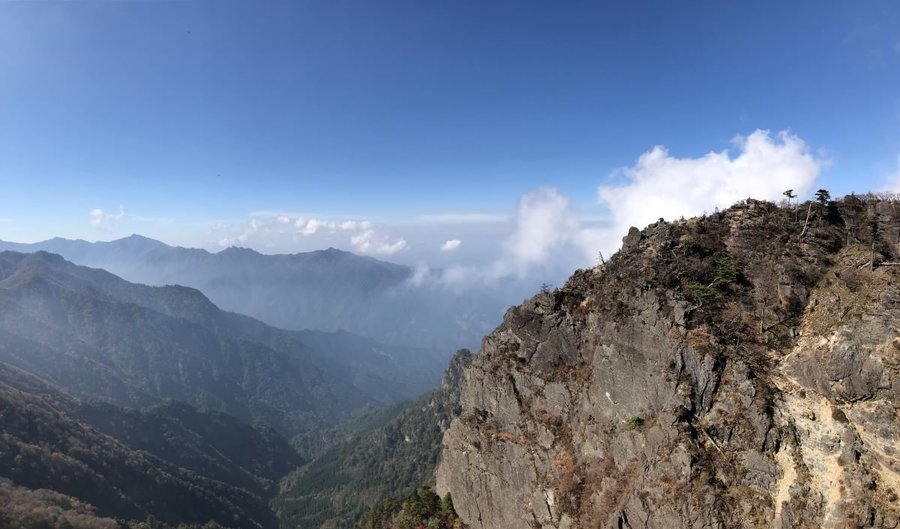
Head for the summit that offers a great panorama over the Sobo-Katamuki Mountain Ranges.
-
- Duration
- 1Day / 5Hours
- Highest Point
- 1605m
- Elevation Gain
- 540m
-
- Skill Level


- Fitness Level
- Gear Level
Park your car at the parking space by the forestry road and start hiking. Continue on along the road for a while until it gets narrower and turns into a mountain path. About 30 minutes from the parking space, you will arrive at the only place to get water, make sure to fill up with water here.
10 more minutes of steep ascending from the watering place will take you to Tsuzura-goe Pass, which is the pass on the ridgeline that connects Mt. Sobo (Sobo-san) and Mt. Katamuki. From here the path turns into a broad and pleasant walk on the ridge. Surrounded by a pleasant natural forest, the path is especially beautiful from late April to early May when Akebonotsutsuji (Rhododendron pentaphyllum var. shikokianum) is in bloom.
Proceed eastward past Mt. Sengen (Sengen-yama), and the goal, the rocky summit of Mt. Katamuki comes into sight. Mt. Katamuki consists of three rocky peaks, each of which is referred to as Ushiro-katamuki, Hon-katamuki and Mae-katamuki respectively. Soon the path turns into a rocky zone just about where the path from Sugigagoe Pass merges, but it should not be a problem if walked carefully.
Hike over Ushiro-katamuki and up the steep ascent, you will arrive at the summit of Mt. Katamuki. A great 360-degree panoramic view can be enjoyed from the summit. For the return hike, follow the same course in reverse.
Gallery
Other Info
The vertical cliff near the summit is the symbol of Mt. Katamuki and is known as the location of a Japanese folktale titled “Kissaku-otoshi”, which tells the tragic tale of a man left behind on the precipitous cliff.
High Season:April to June, October to November
Notes
The Kuronita forestry road that leads to the trailhead is a narrow, winding unpaved road. Since the rough road goes on for about 10 km, it is preferable to take off-road type cars with higher vehicle height. Also, fallen rocks often block the road after heavy rains or typhoons. Confirming the condition with the Hinokage Tourism Association in advance is highly recommended.
Route Map
Elevation Map
Height (m)
Horizontal Distance (km)
Spec
- Duration
- 1Day / 5Hours
- Highest Point
- 1605m(Mt. Katamuki)
- Elevation Gain
- 540m
- Horizontal Distance
- 6.2Km
- Skill Level
- Fitness Level
- Gear Level
On the Trail
- Sleeping
Tsuzuragoe-koya (shelter hut)
- Eating
Roadside Station Seiunbashi
- Hot-Springs
Hinokage-Onsen Station


