


Mt. Kuromi : Round Trip from the Yodogawa Trailhead
-
- Duration
- 1Day / 7Hours
- Highest Point
- 1831m
- Elevation Gain
- 463m
-
- Skill Level


- Fitness Level
- Gear Level
Start your hike at the Yodogawa Trailhead. Continue along the relatively level trail through the forest past large stumps and fallen trees. After about 45 minutes you'll arrive at Yodogawa -koya mountain hut.
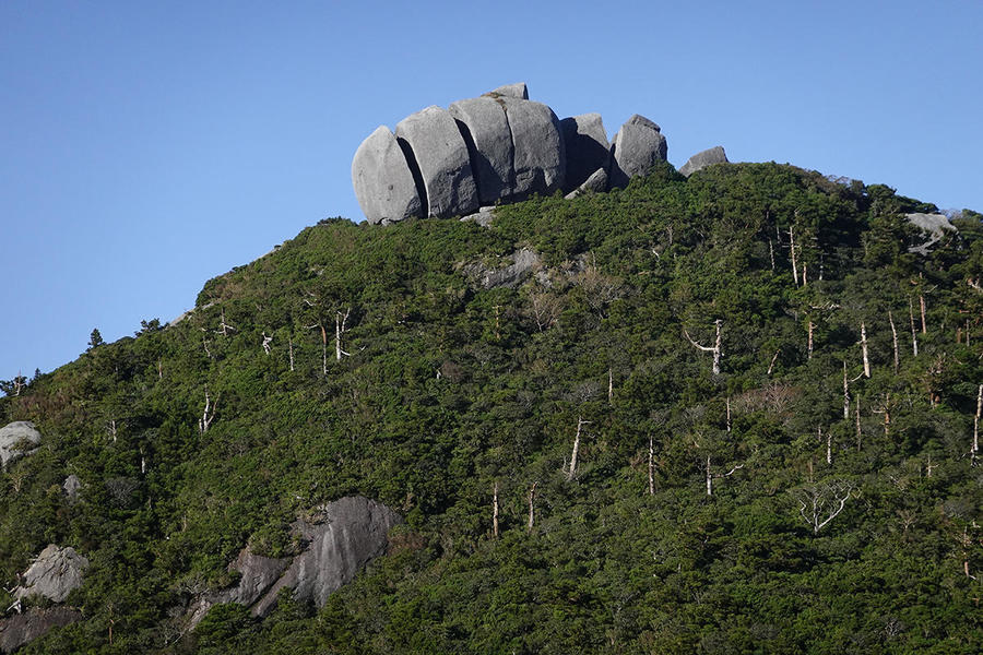
The real ascent starts once you cross the bridge over the river. In places there are thick tree roots and fallen trees over the trail. As you ascend, you'll reach a lookout with a view of Mt. Koban (Kohban-dake) with its large exposed boulder peak known as Tofu-iwa Rock.
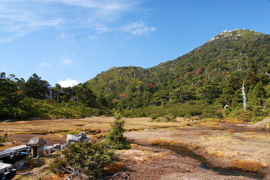
Descend for a short distance and you'll reach Kohananoego, a small wetland. Walk for another 20 minutes and you will arrive at Hananoego which resembles a Japanese garden.
From there it's approximately 25 minutes to the Mt. Kuromi-dake junction. Follow the sign towards Mt. Kuromi. Continuing from there, after a while you'll encounter granite rock with ropes to hold onto as you climb. It's not particularly difficult, just take care and climb at your own pace.
As you approach the summit, there are spots where the trail narrows and steepens, so proceed with caution. About 40 minutes from the junction you'll arrive just below Mt. Kuromi.
Follow the trail to the left of the granite summit and scale the rock with the help of the simple fixed-ropes . A short final walk will bring you to the top. From there the superb 360-degree view takes in Mt. Miyanoura (Miyanoura-dake), Mt. Nagata (Nagata-dake), and Mt. Kurio (Kurio-dake).
Return the way you came.
Gallery
Other Info
You'll be able to see two highland marshes during your hike to the summit. Kohananoego is Japan's southernmost highland marsh. The moss-covered wetland with its rain and meltwater fed ponds and bone-white trees create a scene not unlike a Japanese garden.
Hananoego has a boardwalk. To protect the environment, leaving it and walking through the wetland is prohibited. From May to June, you can see flowers endemic to Yakushima such as Yakushima shakunage (Rhododendron yakushimanum) and sakura tsutuji (Rhododendron tashiroi Maxim).
High Season:April to June, September to November
Notes
When visiting Yakushima with its heavy rains you’ll need proper rain gear. Be aware that when typhoons occur between summer and autumn, transport to the main Kyushu island may be interrupted. Mt. Kuromi's granite summit has no ropes or fences around it, so watch your step.
Route Map
Elevation Map
Spec
- Duration
- 1Day / 7Hours
- Highest Point
- 1831m(Mt. Kuromi)
- Elevation Gain
- 463m
- Horizontal Distance
- 11.1Km
- Skill Level
- Fitness Level
- Gear Level
On the Trail
- Sleeping
Yodogo-koya (an unmanned shelter)
- Eating
- -----
- Hot-Springs
Hirauchi-kaichu Onsen


