


Loop of the Northern Yatsugatake Volcanic Group Mt. Kitayokodake and Mt. Tateshina from Tsuboniwa Lava Plateau
-
- Duration
- 2Day / 10.5Hours
- Highest Point
- 2531m
- Elevation Gain
- 1440m
-
- Skill Level


- Fitness Level
- Gear Level
Departing from Ropeway Sancho Station, the lava plateau known as Tsuboniwa extends in front of you. Walk along the promenade and take the fork to the left, and follow the zigzag hiking path through the conifer forest. After hiking from Sancho Station for about an hour, you will arrive at Kitayokodake Hutte.
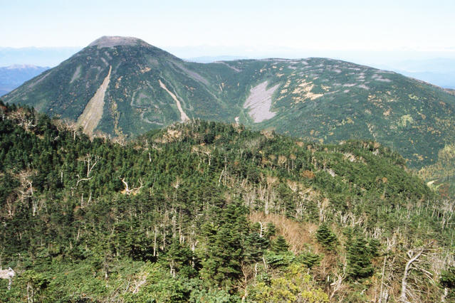
Hiking straight up the steep slope from Kitayokodake Hutte for about 10 minutes will bring you to Mt. Kitayokodake, which consists of two peaks. After descending through the conifer forest slope for about an hour, you will arrive at Kikko-ike Pond.
Descending for about another 20 minutes from Kikko-ike Pond, you will reach a grassy field. Proceeding to the left for about 15 minutes, there is the trailhead to Mt. Tateshina. Hiking up the steep slope of the rocky section for about 80 minutes, you will reach Shogun-daira, and Tateshina-sanso mountain hut, the first night’s accommodation.
Day 2 starts with a round trip to Mt. Tateshina. You will hike straight up the slope where large rocks are piled up on top of one another. Walking past the front of Tateshina Sancho Hutte, the conifer forest starts to turn into shrubs and you will arrive at Mt. Tateshina. The central part of vast, flat summit is the old crater, which now houses a small Shinto shrine and a “torii” gate. Descending for about 30 minutes, you’ll get back to Shogun-daira.
Hiking back up the gentle ridgeline from Shogun-daira, then down the slope through a conifer forest, hikers will arrive at Ogawara-toge Pass after about an hour and 10 minutes. Here you will find parking spaces, toilets and Ogawara Hutte.
From Ogawara-toge Pass, it takes about 50 minutes to get to Futago-ike Pond after hiking across Mt. Futago (Futago-yama), which is a stretch of gently sloping grasslands. Futagoike Hutte stands right between the two ponds located side by side.
Proceeding on a flat forest from Futago-ike Pond for about 10 minutes, there is a paved path. Taking the shortcut on the paved path and continuing hiking for about 30 minutes, you will come to a bridge. Crossing the bridge, you will find the trailhead located at the right-hand side. Hiking up the gentle slope through the forest, you will reach Ama-ike Pond in about an hour.
Head for Amaike-toge Pass, with the pond on your left and walk on a forestry road through a grass field for a while. Hike up the steep hill in the forest, then you will arrive at Amaike-toge Pass in about 70 minutes. Descending about 20 minutes from Amaike-toge Pass via Shimagare-sanso mountain hut, brings you back to Tsuboniwa and Ropeway Sancho Station.
Gallery
Other Info
High Season:May to October
Notes
Day 2 of this route requires long walking hours filled with ups and downs. If continuing becomes difficult due to physical condition or weather change, take the descending route to Gosensui Natural Garden from Shogun-daira, after coming down from Mt. Tateshina. Walking time will be about an hour and 15 minutes via Mt. Tateshina’s seventh station trailhead. Take the gondola lift from there to Tateshina-bokujo Ranch, then take Tateshina-cho Community Bus and transfer to Alpico Kotsu Bus to get to Kayano Station in about an hour.
Route Map
Elevation Map
Spec
- Duration
- 2Day / 10.5Hours
- Highest Point
- 2531m(Mt. Tateshina)
- Elevation Gain
- 1440m
- Horizontal Distance
- 21.6Km
- Skill Level
- Fitness Level
- Gear Level
On the Trail
- Sleeping
Kitayokodake Hutte, Tateshina-sanso, Tateshina-sancho Hutte, Ohgawara Hutte, Futago-ike Hutte, Simagare-sanso
- Eating
Kitayatsugatake Ropeway Sky Restaurant Komakusa-tei
- Hot-Springs
Tateshina Onsen Hot Spring Public Bath


