


Mt. Amakazari (Amakazari-yama) is located on the border of Niigata and Nagano prefectures, and is in the Myoko-Togakushi Renzan National Park. Listed among Japan’s 100 most famous mountains, the mountain offers a variety of scenic beauty, including the beech virgin forest in its foothills, steep rock cliffs and alpine plants growing on ridgelines.
There are two major hiking routes: Niigata prefecture route and Nagano prefecture route. This course introduces a round trip route from Otari Onsen hot spring on the Nagano prefecture-side, which has less difference in elevation.
Mt. Amakazari Round trip from Otari Onsen (hot spring)
Round trip through the beautiful mountain famous for beech forest and alpine plants.
-
- Duration
- 1Day / 6.5Hours
- Highest Point
- 1963m
- Elevation Gain
- 792m
-
- Skill Level


- Fitness Level
- Gear Level
From Amakazari-kogen Camp Site, proceed through the flat shrub area along Omi-gawa River. Fork away from Omi-gawa River to get to the slope on the left, and the trail turns into a steep uphill through a broadleaved forest.
Hike through the virgin forest of beech, and a rock cliff appears in front. After about 2 hours of hiking form Amakazari-kogen Camp Site, you will arrive at a dry riverbed known as Arasugezawa, which is a water place. Looking up at the slope on the left, the rocky summit becomes visible.
Hike up the steep slope of the shrub belt from Arasugezawa, and the trail continues on to a rocky section, where ladders are placed in some parts. It takes about an hour and 20 minutes from Arasugezawa to Sasa-daira, where the broad and flat ridgeline continues on. Hike up the steep slope directly under the summit, and you will arrive at Mt. Amakazari, which is about 30 minutes away from Sasa-daira.
The summit consists of two adjacent peaks, the north peak and the south peak. The unobstructed view from the summit offers beautiful scenery including the Northern Japanese Alps, the Kubiki mountain range and the sea of Japan.
Descend the same route to the end of the trail to return.
Gallery
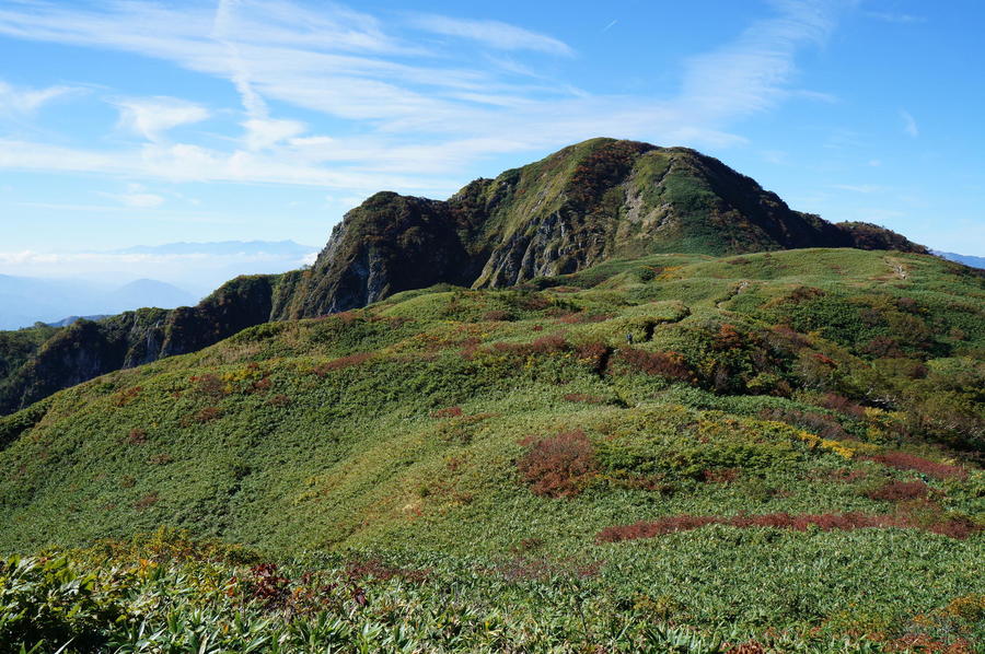
Sasa-daira is a broad and gentle ridge
Other Info
The Kama-ike Pond is located at the foot of Mt. Amakazari, surrounded by the virgin beech forest. It is a very popular spot for amateur photographers. Walk along the paved forestry road from Amakazari-kogen Camp Site for about 50 minutes to get to the administration building at the entrance. It takes about 30 minutes to go around the pond. After the end of autumn foliage in Mt. Amakazari from mid- to late October, visitors appreciate the autumn-colored foliage reflected on the surface of the pond water.
High Season:June to October
Notes
The best time for hiking in Mt. Amakazari is early October, when the beautiful foliage of beech and other broadleaved forest can be enjoyed, and July, when alpine plants on the ridgeline area bloom. In July, snow could still be remaining on the route. Especially in Arasugezawa where snow patches often form, you will need to take extra caution when hiking through.
Route Map
Elevation Map
Height (m)
Horizontal Distance (km)
Spec
- Duration
- 1Day / 6.5Hours
- Highest Point
- 1963m(Mt. Amakazari)
- Elevation Gain
- 792m
- Horizontal Distance
- 7.6Km
- Skill Level
- Fitness Level
- Gear Level
On the Trail
- Sleeping
Otari Onsen Kyukeisha Rest Area
- Eating
Amakazari-so
- Hot-Springs
Amakazari-so, Amakazari-kogen Rotenburo (outdoor hot spring)


