


This area is located in the southwestern part of the Northern Japanese Alps. Mt. Mitsumata-renge (Mitsumata-renge-dake), which is located on the borders between Toyama Prefecture, Nagano Prefecture, and Gifu Prefecture, is also where the Uraginza traverse course from Takase Dam in Nagano Prefecture to Mt. Yarigatake and the Nishiginza Diamond course from Oritate in Toyama Prefecture to Mt. Yarigatake meet. This route will take hikers from Shinhotaka Onsen, the gateway to the Northern Japanese Alps on the Gifu Prefecture side, to the summit of Mt. Sugoroku (Sugoroku-dake) before making a round trip to Mt. Mitsumata-renge and then the summit of Mt. Kasagadake, which is listed as one of Japan's 100 most famous mountains.
Mt. Sugoroku, Mt. Mitsumata-renge, Mt. Kasagadake (Round Trip)
A scenic tour of the solitary southwestern peaks of the Northern Japanese Alps.
-
- Duration
- 3Day / 22Hours
- Highest Point
- 2897m
- Elevation Gain
- 1808m
-
- Skill Level


- Fitness Level
- Gear Level
Starting from Shinhotaka Onsen (Hot spring), walk along the paved forestry road along left bank of the Gamata-gawa River. After crossing the bridge you will precede along a flat gravel forestry road along the right bank of the Gamata-gawa River. After passing where the road forks with Kasashindo you will arrive at the Wasabidaira-goya mountain hut, which is surrounded by a beech forest, about 90 minutes from Shinhotaka Onsen.
As the beech forest ends, you will come out onto a dry riverbed before arriving at where the course forks with the Mt. Okumaru (Okumaru-yama) trailhead. Proceed down the left fork onto the Koikeshindo. Proceed down the cobbled path through the meadow and hike up the rocky trail through the shrub zone. After crossing Chichibu-sawa and Chichibu-kosawa using the simple wooden bridge you will once again come to a rocky trail that continues for some time. As the surrounding area turns to meadows, you will arrive at Shishiudogahara where fields alpine plants bloom from July to August. There are also benches to rest on.
Proceed down the traverse trail from Shishiudogahara and after you pass the Kuma-no-odoriba boardwalk and hike up the rocky section you will arrive at Kagami-daira about 5 hours after leaving Shinhotaka Onsen. The area is dotted with little ponds along the boardwalk. Kagami-ike Pond is especially photogenic because of the way Yarihotaka mountain range is reflected in its surface. After you pass by the Kagamidaira-sanso mountain hut and hike up the rocky trail, the surrounding will change from a shrub zone to a stone pine belt. You will then traverse the right side of Mt. Yumiori (Yumiori-dake) before arriving at the Yumiori fork.
After hiking up and down the ridgeline through a stone pine belt you will pass through a meadow where alpine plants bloom from July to August. The trail will then turn into a landside scar that has been reinforced with wood. Once again a boardwalk will appear and you will pass through a flat stone pine belt before arriving at the Sugoroku-goya mountain hut. This is where you will stay the first night.
Starting early the second day you will start hiking up through the stone pine belt behind the Sugoroku-goya and pass the Makimichi fork, a traversing detour route, and the fork,a route through the mid-slope of the mountain, before proceeding down the rocky trail of the ridgeline route. As the surrounding area turns into a plateau dotted with stone pines and meadows you will arrive at the summit of Mt. Sugoroku about 70 minutes from the Sugoroku-goya. If you look back you will see the beautiful ridgeline of the Yarihotaka mountain range.
Proceed down the gently-sloping ridgeline through the stone pine belt and after you pass over Mt. Maruyama you will arrive at the summit of Mt. Mitsumata-renge about an hour after leaving Mt. Sugoroku. You will return to the Sugoroku-goya via a detour that traverses the left side of the ridgeline you walked to get here.
After returning to the Yumiori fork about 70 minutes from the Sugoroku-goya and taking the right fork, you will hike up and down a ridgeline that connects Mt. Yumiori, Mt. Onoma (Ohnoma-dake), and Mt. Nukedo (Nukedo-dake). After passing the Kasashindo fork and hiking to the top of the rocky trail stone pine belt following the paint marks, you will arrive at the summit of Mt. Kasagadake about 4 and a half hours from the Yumiori fork. You will stay the second night the second night at the Kasagadake-sanso mountain hut located just under the summit.
At the start of the third day, return to the Kasashindo fork and proceeds down the right fork onto the Kasashindo. Zigzag down the slope through the meadow and after you hike back up you will arrive at Shakushi-daira. Zigzag down the steep slope that changes from a shrub zone to a broadleaf forest and then to a conifer forest. You will arrive at the Kasashindo trailhead about 4 and a half hours from the Kasashindo fork.
Return to Shinhotaka Onsen via the flat forestry road you passed through on the first day.
Gallery
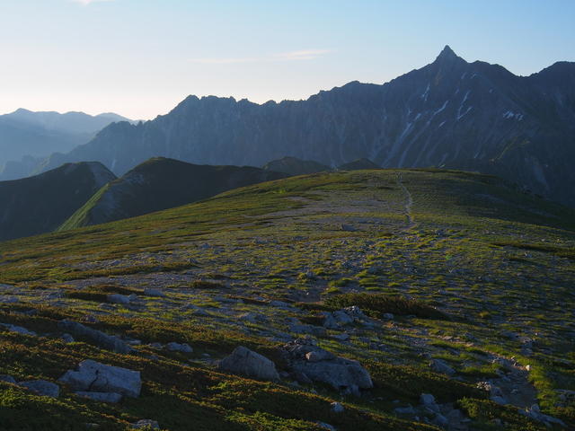
Mt. Yarigatake, as seen from the gentle ridgeline of Mt. Sugoroku.
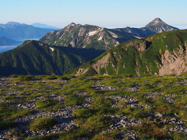
Looking toward Mt. Kasagatake from Mt. Sugoroku.
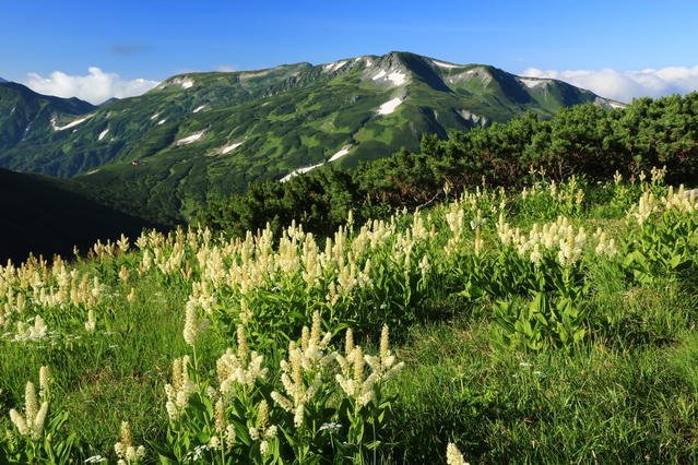
A cluster of kobaikeiso (Veratum staminem) and Mt. Mitsumata-renge.
Other Info
This route is located on the west side of the Yarihotaka mountain range. Hikers will be treated to the beautiful sight of the Yarihotaka mountain range bathed in twilight. This fascinating sight has been featured in the works of many photography enthusiasts as well as in many Instagram posts and elsewhere.
Best Season:July to September
If you go to this trail outside of the best season, you should pay attention to weather and trail conditions, as the mountain is located in a snowy area; there may still be snow on the trail in July, and it may start snowing from October. Snow mountaineering equipements and experience are required during the winter season.
Notes
Route Map
Elevation Map
Height (m)
Horizontal Distance (km)
Spec
- Duration
- 3Day / 22Hours
- Highest Point
- 2897m(Mt. Kasagadake)
- Elevation Gain
- 1808m
- Horizontal Distance
- 37.4Km
- Skill Level
- Fitness Level
- Gear Level
On the Trail
- Sleeping
Wasabidaira-goya, Kagamidaira-sano, Sugoroku-goya, Mitsumata-sanso, Kasagadake-sanso
- Eating
Shinhotaka-Onsen Station Kissa & Keishoku Kasagadake
- Hot-Springs
Shinhotaka-no-yu


