


These mountains and spots are located at the heart of the Northern Japanese Alps. The traverse course from Bunatate-one Ridge to Mt. Yarigatake starting from Takase Dam is commonly referred to as Ura-ginza. The route is well-suited for those who enjoy quiet hikes because it has relatively few hikers compared to the Omoteginza course. This is a course that aims for Kumono-daira, the highest lava plateau in Japan, via three peaks counted among Japan's 100, 200, and 300 most famous mountains.
Mt. Eboshi, Mt. NoguchiGoro, Mt. Suisho, and Kumono-daira Traverse
Enjoy the famous mountains and secluded spots of the deep Northern Japanese Alps.
-
- Duration
- 4Days / 25.5Hours
- Highest Point
- 2986m
- Elevation Gain
- 1714m
-
- Skill Level


- Fitness Level
- Gear Level
After disembarking from your taxi at Takase Dam, walk across the dam body, go through Fudosawa Tunnel, and then cross Fudosawa Bridge. Proceed along the broad dry riverbed until you reach the approach to Bunatate-one Ridge. Fill your water up at the watering hole and walk up the steps before hiking up the steep slope through a forest of buna (Japanese beech) and kometsuga (northern Japanese hemlock).
As the trail transitions to a ridge you will then pass Tanuki-iwa Rock before climbing up a trail with ladders and ropes. As the trees along the ridge turn into shrubs such as dakekanba (Erman's birch) and nanakamado (Japanese rowan) you will eventually come to the main ridge line and arrive at the Eboshi-goya mountain hut. From Eboshi-goya you will precede along a pebbled trail through stone pines and granite stones before passing over Mt. Niseeboshi (Niseeboshi-dake) and arriving at the Eboshi fork. As you pass the section with chains and climb up the rocky area, you will arrive at the summit of Mt. Eboshi (Eboshi-dake). Head back to Eboshi-goya, where you will stay the first night.
At the start of day two you will pass by Hyotan-ike Pond and hike up the pebbled slope through the stone pine belt. Skirt the slope on the right side of Mt. Mitsudake and proceed along either the Alpine flower zone route or the ridgeline route. After both routes come together you will pass through a narrow ridgeline which will eventually widen out. The Noguchigoro-goya mountain hut is located at the col beyond this point.
After hiking back up the other side you will arrive at Mt. Noguchigoro (Noguchigoro-dake). Skirt the right side of Mt. Masago (Masago-dake) while looking down at Goro-ike Pond to the right below and pass the Takemura-shindo fork. As you go over Higashizawa Nokkoshi while hiking up and down through a rocky section with lots of large rocks the trail will turn into a reddish-brown rocky section and you will arrive at the Suisho-goya mountain hut. From the Suisho-goya you will climb the rocky area using the ladders installed there before skirting the three rock peaks from the left side. You will then arrive at the peak of Mt. Suisho (Suisho-dake). Return to the Suisho-goya, which is where you will stay the second night.
On the start of the next day, you will pass the Warimo-kita fork and hike down the ridgeline through the stone pine belt to Iwagoke Nokkoshi. From here you will hike up a rocky section and after you pass over Mt. Jii-dake you will descend through a meadow and pass a boardwalk through the stone pine belt before arriving at Kumono-daira. At Kumono-daira there is a long gently-sloping boardwalk through the marshlands, which are dotted with rocks of various sizes. There is a camping ground located at the foot of Mt. Jii-dake. At the center of the plateau is the Kumonodaira-sanso mountain hut and places of scenic beauty called the Swiss Garden, Greek Garden, and Alps Garden.
After you pass the Alaska Garden, the boardwalk will end and the trail will descend down a steep rocky area through the forest belt for quite some time. After climbing down the long ladder, you will arrive at Yakushizawa and cross the suspension bridge. After passing the Yakushizawa-goya mountain hut you will walk up a gently-sloping boardwalk through the through the meadow of Kabekkegahara, which becomes an Alpine flower zone from June to August. After crossing the wooden bridge with no handrails you will hike along a stream. As you come to the top of a slope with a boardwalk through shrubs and meadows you will arrive at the Tarodaira-goya mountain hut, which is where you will stay the third night.
At the start of the next day, walk down the cobbled gently sloping grassy ridge and then walk along the long boardwalk. Finally, you will hike down the steep slope through the forest line and arrive at Oritate trailhead about 3 hours after leaving the Tarodaira-goya.
Gallery
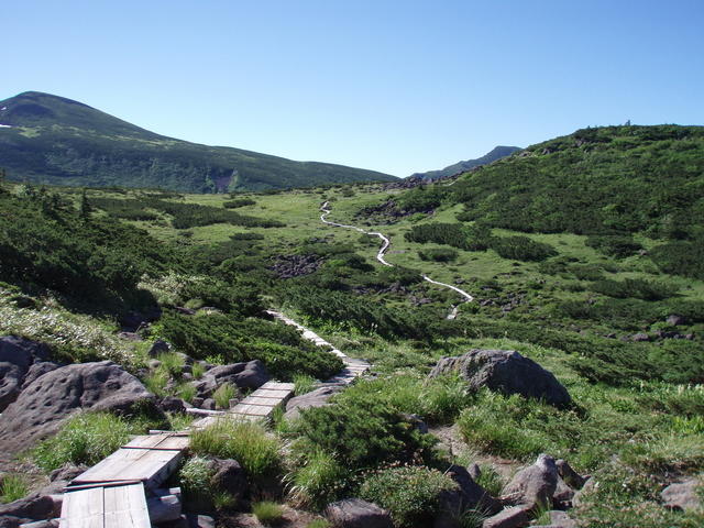
Kumono-daira, a gently sloping lava plateau.
Other Info
Although it will require additional overnight stays, a great secluded spot of the Northern Japanese Alps to visit is Takamagahara, which is located about 2 and a half hours from Kumono-daira. This place of scenic beauty at the foot of Mt. Suisho is dotted with ponds and marshlands. There is also the Takamagahara Onsen (Hot spring), which has a liberating open-air bath in the middle of a dry riverbed, about a 20-minute walk from the Takamagahara-sanso mountain hut. There is even an open-air bath just for women with a changing area in closed by bamboo screens.
Best Season:July to September
If you go to this trail outside of the best season, you should pay attention to weather and trail conditions, as the mountain is located in a snowy area; there may still be snow on the trail in June, and it may start snowing from October. Snow mountaineering equipements and experience are required during the winter season.
Notes
Route Map
Elevation Map
Height (m)
Horizontal Distance (km)
Spec
- Duration
- 4Days / 25.5Hours
- Highest Point
- 2986m(Mt. Suisho)
- Elevation Gain
- 1714m
- Horizontal Distance
- 35.2Km
- Skill Level
- Fitness Level
- Gear Level
On the Trail
- Sleeping
Eboshi-goya, Noguchigoro-goya, Suisho-goya, Kumonodaira-sanso, Yakushizawa-goya, Tarodaira-goya
- Eating
Arimine Memorial Hall
- Hot-Springs
Arimine House


