


Mt. Yufu (Yufu-dake) is an independent active volcanic mountain located in Oita Prefecture, which is located in the northeast of the Kyushu region. It has twin peaks; west and east peaks (seiho and toho) at its summit, with an old volcanic crater, named Ubagauji, directly under it. The beautiful conical shape of the mountain has earned the title of “Bungo Fuji (Mt. Fuji of the Bungo region)” among the residents at the foothills and has also been an object of religious faith. Among the three hiking trails extending from the east, south and west sides, this course introduces the round-trip course originating from the shorter south trail starting from the front trailhead.
Round Trip of Mt. Yufu from the Front Trailhead
Beautiful twin peaks surrounded by hot springs.
-
- Duration
- 1Day / 6.5Hours
- Highest Point
- 1583m
- Elevation Gain
- 806m
-
- Skill Level


- Fitness Level
- Gear Level
Yufu-tozanguchi bus stop is the entrance to the front trailhead.
Proceed through pastureland and hike up the trail through a broadleaf forest for approximately 40 minutes and hikers will arrive at the fork named Goyagoshi.
Proceed on the slope to the north and the trail turns into a steep zigzagging slope through a shrub zone. Hike up the grassland slope and hikers will arrive at the spot called Matae, located on the crater wall that constitutes the summit area, in approximately an hour and 10 minutes.
Although the west peak of Mt. Yufu is only approximately 40 minutes round-trip, it has a steep and precipitous rock ridge with supportive chains where hikers need to take extra caution. Hike up the steep ascent through the rocky section from Matae for approximately 20 minutes and hikers will arrive at the east peak of Mt. Yufu. The summit offers a view so spectacular that, if the weather is clear enough, even Shikoku, one of the four main islands of Japan, will be visible.
Proceed on the ridgeline of the crater wall and take the eastward descent at the fork, then the trail turns into a steep downhill with supportive chains. Entering the broadleaf forest, hikers will arrive at the Hyugagoshi fork where a statue of Jizo stands, in approximately an hour from the east peak.
Proceed southward on the fork and traverse down into the forest and past Mt. Hyuga (Hyuga-dake), then the trail merges with the front trailhead. Hikers will arrive at the Yufu-tozanguchi bus stop in approximately 50 minutes.
Gallery
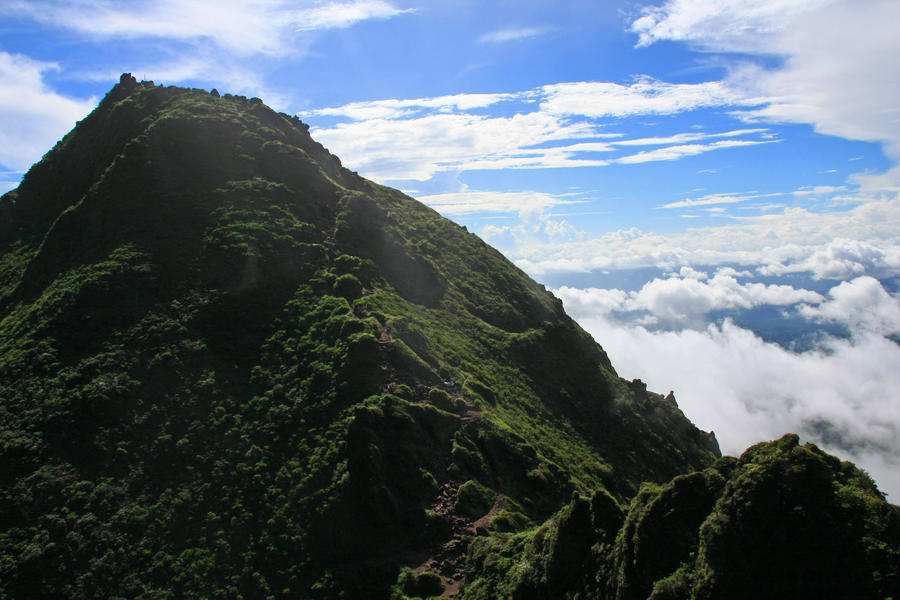
The east peak of Mt. Yufu.
Other Info
Mt.Yufu is located close to one of the greatest hot spring areas in Japan. Beppu Onsen hot spring on the eastern foot is one of the best hot spring resorts in Japan in terms of both number of hot spring wells and the yield of hot water. Yufuin Onsen hot spring on the western foot is the second in Japan in the same two categories and is known for its unique nature conservation and landscape protection policies based on that of European hot spring resorts.
High season:April to June, October to November
Notes
Hikers need to take caution not to slip or fall while hiking the precipitous trail along the crater walls that continues on a ridgeline forming the summit area. Neither trail nor mountain huts are equipped with water places, so hikers are strongly advised to prepare enough water supply prior to starting the hike.
Route Map
Elevation Map
Height (m)
Horizontal Distance (km)
Spec
- Duration
- 1Day / 6.5Hours
- Highest Point
- 1583m(Mt. Yufu (west peak))
- Elevation Gain
- 806m
- Horizontal Distance
- 7Km
- Skill Level
- Fitness Level
- Gear Level
On the Trail
- Sleeping
- -----
- Eating
Vicinity of Beppu Onsen and Yufuin Onsen hot springs
- Hot-Springs
Beppu Onsen, Yufuin Onsen


