


Traverse of Mt. Iwate from Yakehashiri to Nana-taki Falls
-
- Duration
- 1Day / 7.5Hours
- Highest Point
- 2038m
- Elevation Gain
- 1469m
-
- Skill Level


- Fitness Level
- Gear Level
Hike up through the forest belt from the Yakehashiri trailhead and you will arrive at the Daini Funshutsuko-ato spout in about one and a half hours. After coming out the forest belt, the trail will transition to a surface covered in volcanic pebbles and in about an hour and 10 minutes you will arrive at Tsuruhashi, where the trail meets with the Uwabo course.
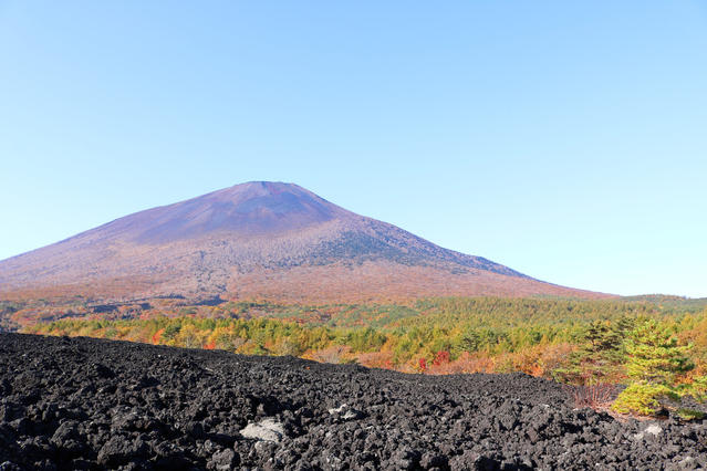
Once again you will traverse up the trail through a shrub zone you will arrive at the Hirakasafudo-hinan-goya shelter hut about an hour from Tsuruhashi. From the Hirakasafudo-hinan-goya you will hike up a pebbled trail over the shrub zone and arrive at the ridgeline of the somma of the summit. From here you will circle the crater rim clockwise. About 40 minutes from the Hirakasafudo-hinangoya you will arrive at Mt. Yakushi (Yakushi-dake), the highest peak of Mt. Iwate.
Proceed further around the crater rim ridgeline while looking down at the summit crater to the right. You will eventually arrive at the fork that leads down to Fudo-daira. From here you will leave the crater rim ridgeline and hike down a pebbled trail through a stone pine belt. You will arrive back at the Fudotai-hinan-goya shelter hut about 30 minutes after leaving Mt. Yakushi.
As you hike down a slope with stone pines and bamboo grass and proceed through a gently-sloping conifer forest belt, you will arrive at the Ohanabatake fork, which is surrounded by marshlands, in about 40 minutes.
Proceed along the mountain stream while looking up the Onigajo rock ridge to the left and the slope of the crater rim to the right before hiking back up. You will arrive at the Ohjigoku fork in about 30 minutes.
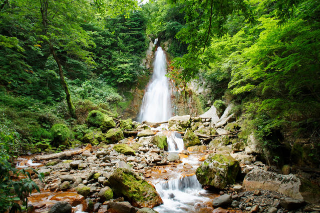
Descend the steep and slippery pebbled slope, which has ropes installed at the important points. As you cross the left bank of Ohjigoku Valley you will come upon a trail that traverses through a forest belt along a stream. Along the way you will be able to see a number of waterfalls including Nana-taki Falls.
After leaving the stream and hiking down through a conifer forest belt you will arrive at the Nanataki trailhead in about an hour and 40 minutes after passing the Ohjigoku fork.
Gallery
Other Info
In July hikers can enjoy seeing the massive colony of komakusa (dicentra) that grows on the pebbled slopes of the Yakehashiri course. The surrounding shrubs and trees are also decorated in brilliant autumn colors from late September to early October.
Best Season:July to early October
If you go to this trail outside of the best season, you should pay attention to weather and trail conditions, as the mountain is located in a snowy area; there may still be snow on the trail in June, and it may start snowing from October. Snow mountaineering equipements and experience are required during the winter season.
Notes
The Nanataki course that hikers take down the mountain on this route offers a good variety of scenery to enjoy. However, hikers must be aware of the slippery slopes, fumaroles, and other hazards around the Ohjigoku area. Because the course is quite long, hikers may need to consider taking the outbound route back down the mountain depending on what time they arrive at the summit of Mt. Yakushi, their physical condition, and other factors.
Route Map
Elevation Map
Spec
- Duration
- 1Day / 7.5Hours
- Highest Point
- 2038m(Mt. Iwate・Mt. Yakushi)
- Elevation Gain
- 1469m
- Horizontal Distance
- 16.4Km
- Skill Level
- Fitness Level
- Gear Level
On the Trail
- Sleeping
Hirakasafudo-hinan-goya, Fudotai-hinan-goya
- Eating
Hachimantai Onsenkan Morinoyu
- Hot-Springs
Hachimantai Onsenkan Morinoyu


