


Mt. Io-dake, Mt. Yoko-dake, Mt. Aka-dake, and Mt. Amida (Amida-dake) are located on the border between Nagano Prefecture and Yamanashi Prefecture and are part of the Southern Yatsugatake Mountains (Minami-Yatsugatake or Yatsugatake-renpo). Each has its own unique characteristics, whether it is Mt. Io-dake, notable for its gently sloping summit and the cliffs on its northern face, Mt. Yoko-dake, which is comprised of multiple rock peaks, Mt. Aka-dake, the tallest peak in the Yatsugatake Mountains, or Mt. Amida, with its imposing shape. All four are above the tree limit. Hikers can enjoy traversing these mountains while taking in views of the virgin forests below and of Mt. Fuji (Fuji-san), the Okuchichibu Mountains, and the Southern Japanese Alps in the distance. Here we will introduce a route that starts from Minotoguchi, which has good convenience of access, and loops around all of these four mountains.
Loop of the Southern Yatsugatake Volcanic Group Mt. Io-dake, Mt. Yoko-dake, Mt. Aka-dake, Mt. Amida
-
- Duration
- 2Days / 13Hours
- Highest Point
- 2899m
- Elevation Gain
- 1409m
-
- Skill Level


- Fitness Level
- Gear Level
Start walking the unpaved road from Minotoguchi. In about an hour you will arrive at Minoto, which has three mountain huts. Cars can pass up to this point, so be careful. After you cross the bridge you will come to the fork that leads to Kitasawa and Minamisawa, respectively. After passing Minoto and crossing the bridge you will arrive at the fork that leads to Kitasawa and Minamisawa, respectively.
Proceed along the mountain stream and come out of the conifer forest belt before hiking up the rocky trail. As the ridgeline of Mt. Yoko-dake grows closer in front of you, you will arrive at the Akadake-kosen mountain hut about 2 hours after passing Minoto. As the Alpen increases the vegetation will trim transition from shrubs to stone pines and you will arrive at Akaiwa-no-Kashira about 2 hours after passing Akadake Kosen.
Hike up the gently-sloping ridgeline and you will arrive at Mt. Io-dake in about 20 minutes after passing Akaiwa-no-Kashira. There you will be able to enjoy a 360-degree view from the broad, flat summit. To the south you will be able to see the Mt. Yoko-dake, Mt. Aka-dake, and Mt. Amida, which you will be heading to the next day.
The Iodake-sanso mountain hut is located in a col about a 20-minute hike down from Mt. Io-dake. This is where you will stay the first night.
At the start of the second day you will head towards Mt. Yoko-dake.The trail will be gentle until you reach a repeat called Daiza-no-Kashira. From this point the trail will become a rocky ridge.
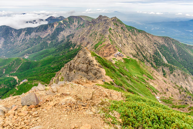
After traversing the narrow rock ridges and the plank roads, and climbing up to the ridgeline via the ladders and chains, you will arrive at Mt. Yoko-dake (highest point: Okuno-in) about 50 minutes after leaving the Iodake-sanso. Pass over the rock peak, climb down using the chains and ladders, and make several traverses to pass the rock ridge. You will arrive at Jizo no Kashira about 45 minutes after leaving Okuno-in. If the weather is clear, your next destination Mt. Aka-dake will be looming large ahead of you.
Pass the Akadake-tenbo-so mountain hut, hike up the zigzagging trail through the stone pine belt, pass the Akadakechojo-sanso mountain hut, and you will arrive at the summit of Mt. Aka-dake, the highest peak in the Yatsugatake Mountain Range, about 45 minutes from Jizo-no-Kashira. You will be able to see Mt. Fuji (Fuji-san) and the mountains of the Southern Japanese Alps not so far away.
Climb down the rocky area dotted with chains, pass the fork, and go over Mt. Nakadake. Then hike up the steep slope from the col via the chains and ladders. You will arrive at the summit of Mt. Amida about 1.5 hours after leaving the summit of Mt. Aka-dake.
Take the path you hiked up down to the col before the zigzagging down through the shrub zone and the conifer forest belt and you will arrive at the Gyoja-goya mountain hut in about 50 minutes. From the Gyoja-goya you will hike down to Minami-sawa. Proceed along the trail through the broad riverbed, crossing the mountain stream many times, before traversing down the slope. After passing over the large dam you will arrive at Minoto about an hour and 40 minutes after leaving the Gyoja-goya.
Take the path you originally took to Minoto back down to Minotoguchi.
Gallery
Other Info
Although this particular route loops these four mountains, the Southern Yatsugatake Mountains is dotted with many mountain huts, allowing hikers to design a wide variety of routes.
For example, you could make a round trip to Mt. Io-dake starting from either Akadake Kosen, which you will pass on the route introduced above, or from the Ohren-goya mountain hut in the northern base, or from the Natsusawa Kosen mountain hut. Another route would be a looping round trip Mt. Aka-dake and Mt. Amida starting from the Gyoja-goya.
Depending on the weather and your physical condition, it may be a good idea to narrow down the destinations of your hike to the mountains with the highest priority.
High Season:June to October
Notes
There is a danger of slipping and falling when passing the rock ridge around Mt. Yoko-dake. There is also a danger of falling rocks and falling down in the rocky areas around Mt. Aka-dake and Mt. Amida. We recommend wearing a helmet when hiking along rock ridges above the tree line.
Route Map
Elevation Map
Spec
- Duration
- 2Days / 13Hours
- Highest Point
- 2899m(Mt. Aka-dake)
- Elevation Gain
- 1409m
- Horizontal Distance
- 21.6Km
- Skill Level
- Fitness Level
- Gear Level
On the Trail
- Sleeping
Yatsugatake-sanso, Akadake-sanso, Minoto-sanso, Akadake Kosen, Iodake-sanso, Akadake-tenboso, Akadakechojo-sanso, Gyoja-goya
- Eating
Yatsugatake-sanso, Akadake-sanso, Gyosha-goya
- Hot-Springs
Momi-no-yu


